Advertisement
Hidden Ireland

Hidden Ireland: Have you seen this ancient carving of a hurley and sliotar?

For the All-Ireland hurling replay day that’s in it, check out that historic gem (in Donegal!) and others in Tipperary and Tyrone as part of Neil Jackman’s bi-weekly series.

image

Guess where this is? Hint: It’s not in Cork nor Clare.

ENJOY THE CONTINUING mild weather this weekend and visit one of Ireland’s many wonderful heritage sites.

Here are three more suggestions, an incredible medieval abbey in Tipperary, the crowning place of the O’Neills in Tyrone and a small church at the very northern tip of Ireland in Donegal where you can find one of the earliest representations of a hurley and sliotar in the country (Yes, Donegal, not traditionally a hurling stronghold!)

Kilcooley Abbey, Co Tipperary

image

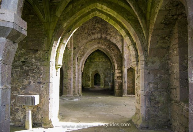
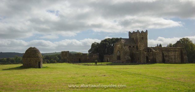
One of Ireland’s true hidden gems, Kilcooley Abbey (pictured, top) is a simply wonderful place to visit. It is located in the beautiful Sliabh-Ardagh region of Tipperary, and is located within the walls of the Kilcooley estate, an impressive Georgian house with over a thousand acres of land (now available for the bargain price of €2.1m!).

Kilcooley Abbey was founded in 1182 after a grant of land to the Cistercians by Donal Mor O’Briain, King of Munster. It was the ‘daughter house’ of Jerpoint Abbey in County Kilkenny, and Kilcooley is without a doubt one of Ireland’s finest Cistercian abbeys and is a wonderful example of Gothic architecture.

I haven’t been able to find much on the next couple of centuries of Kilcooley’s history, but the Abbey is recorded as being attacked and burned in 1418 and later again it was recorded as being almost completely levelled by an armed force of men in 1444.

After this attack, the Ormond Butlers instigated a programme of reconstruction which removed the nave aisles and added a new north transept and tower. Most of the stunning sculpture around the Abbey dates to this period of reconstruction and renovation under the patronage of the powerful Ormond Butlers.

The works were carried out under the eye of the Abbot, Philip O’Mulwanayn, and his graveslab dating to 1463 shows him holding his bishop’s crozier and book of prayer. He appears to have been part of a dynasty, as his son William, and his ancestors after him, were abbots of Kilcooley until the mid-sixteenth century.

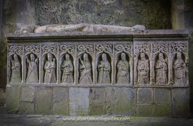
The Butlers were rewarded for their patronage by having their tombs placed inside the sacred areas of Kilcooley. The most stunning of which is the incredible tomb of Pierce Fitz Og Butler.

image

The tomb likely dates to 1526, and depicts Pierce Butler in his armour. At his feet a small dog indicates his faithfulness and loyalty, and ten of the twelve apostles are depicted below. Unusually, we know who actually created the tomb, as the name of the sculptor Rory O’Tunney (Roricus O Tuyne) is clearly marked.

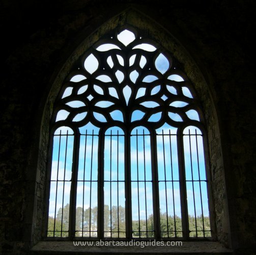
It is almost impossible to do justice in this short article to the sheer wealth of incredible sculpture at Kilcooley, for example the ornate Gothic east window is beautifully carved, with the stone formed to look almost like flames or delicate foliage.

image

The ‘abbots chair’ (or sedilla) is also incredible, and is matched on the other side by another, slightly plainer example.

The screen wall separating the southern transept from the sacristy is also elaborately decorated with a number of scenes including Saint Christopher crossing a river with the infant Jesus, the crucifixion with Mary and Saint John on either side, a pelican feeding its young within a chalice, a charming mermaid with a comb and mirror, and the Butler coat-of-arms.

Beyond this area you can enter the cloister. The cloisters was an important feature of Cistercian monasteries, and were always located to the south. They were usually a covered walkway enclosing an open square area. Very little remains of any covered walkway at Kilcooley, and it appears that perhaps the cloisters were converted to a courtyard in its later history. You can see other more domestic quarters at Kilcooley though some of these are kept locked and inaccessible to the public for health and safety reasons.

Outside of the abbey you can see a small circular tower, this was a dovecote where the monks kept pigeons. The pigeons were a handy source of protein and the pigeon dung also made good fertiliser: very little was wasted in a medieval monastery!

In its heyday, the Abbey would have also had other agricultural buildings like mills and a large lay population to work the land.

Kilcooley Abbey ceased to be a place of monks and contemplation when it was surrendered during the Dissolution of the Monasteries in 1540. However the lands were granted directly to the Butlers, and it is recorded that they allowed monks to remain at Kilcooley, until they sold it to Sir Jerome Alexander in 1636.

image

After the Catholic Confederacy rebellion in 1641, Cistercian monks returned to Kilcooley, until they were finally removed from the site by Cromwell’s forces in 1650. Ten years later the Alexander family regained the Abbey and when Elizabeth Alexander married Sir William Barker of Essex in 1676, the Abbey was converted into being a domestic house.

In 1790 the grand Kilcooley House was built and replaced the abbey as the main residence. Today the site is a National Monument, and under the care of the Office of Public Works. The site is gated, but the gate is often left unlocked during the day to allow visitors to enjoy one of the finest heritage sites in the country.

Kilcooley is located around 20km east of Thurles in County Tipperary, off the R690. It’s just east  of Gortnahoe. When you go up the drive of Kilcooley Estate you’ll see signs for the Abbey, but before you get there be sure to park your car at the relatively modern Church of Ireland and take a moment to see the quite remarkable 18/19th century pyramid shaped burial monument of the Barker family. It’s well worth a look! The abbey is just further along the track, less than a five-minute walk from there.

Tullaghoge, Co Tyrone, ancient kingmaker site of the O’Neills

image

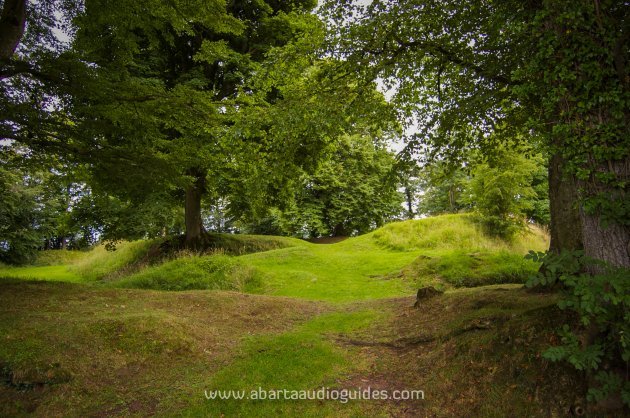
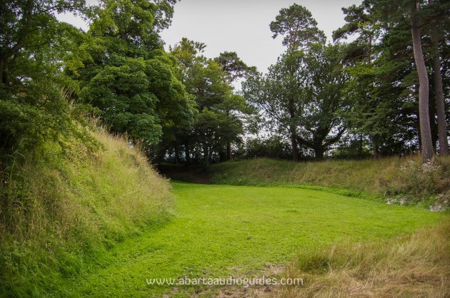
Tullaghoge has to be one of the most atmospheric and evocative sites that we  have visited for this series. At first glance the site looks very much like a large ringfort – a common type of settlement site in the early medieval period. It has a large earthen banks topped by a ring of trees, however the ditches are far too wide to be defensive and the commanding views over the  landscape of Tyrone suggest that this was a place of important ceremonies and authority.

The name Tullaghoge comes from Tulach Óg meaning The Hill of Youth. The site has never been archaeologically excavated so the exact age and function of the initial activity at Tullaghoge is unknown. It is likely to date to some time in the early medieval period, between the seventh and ninth centuries.

Historical records tell us that the site was originally associated with Uí Tuirtre of Airgialla, and then became the possession of the O’Hagan family. They lived at Tullaghoge and became the hereditary guardians of the symbolic site. The O’Hagans were clients of the powerful O’Neill dynasty, and during the middle and later medieval period, it was the O’Hagans who had the honour of inaugurating the O’Neill chiefs, proclaiming them as ‘The O’Neill’.

During the crowning ceremony at Tullaghoge, the King elect was seated on a stone inauguration chair known as the Leac na Ri. He swore oaths to rule by Brehon Law (the ancient laws of Ireland) and to give up the throne if he became too old or infirm to rule.

New sandals were placed on his feet by the chief of the O’Hagans and a golden sandal was ceremonially thrown over his head to indicate he would continue in the footsteps of his ancestors, and then the new king was handed the ceremonial rod of office. The primate of Armagh would then anoint and crown the O’Neill as chief and king.

The last O’Neill to have been inaugurated at Tullaghoge was the famous Hugh O’Neill in 1595. Hugh was the powerful Earl of Tyrone, and he led a massive rebellion against the Crown forces in Ireland in an attempt to stop the plantations of Ireland and the erosion of the powers of the Gaelic chiefs. This series of conflicts became known as The Nine Years War.

After some initial successes, like the Battle of the Yellow Ford, by 1601 the Gaelic forces had suffered a heavy defeat at the Battle of Kinsale. Lord Mountjoy led the Crown Forces here, to the Royal Inauguration site of Tullaghoge, and smashed the Leac na Ri, the sacred inauguration stone of the O’Neills, thereby symbolically breaking the O’Neill sovereignty. At the time it was recorded that Mountjoy ‘spoiled the corn of all the country…and brake down the chair wherin the O’Neals were wont to be created, being of stone planted in the open field’.

image

Fragments of the Leac na Ri were said to have been stored in the orchard of the glebe house of the local protestant church until 1776, when the last of the fragments were taken away.

The O’Neills never returned to Tullaghoge to claim their lordship as Hugh O’Neill fled Ireland in  the Flight of the Earls in 1607. Eventually though the O’Neills would return to power albeit in a more indirect way. Hugh O’Neill’s daughter Sorcha married a Magennis who was the ancestor of Lady Glamis. In 1900 Lady Glamis had a daughter, Elizabeth Bowes-Lyon, her daughter Elizabeth currently sits on the British throne.

The site was said to have been completely abandoned by 1622 and today it is an incredibly atmospheric place to visit. When you enter the centre of the enclosure and are shut off from the modern world by the trees and earthen banks, you can really get a sense of the history of Tullaghoge, a place of celebrations, ceremonies, inaugurations and gatherings for centuries.

Tullaghoge is just around 4km south of Cookstown in County Tyrone, off the B162 (Cookstown to Stewartstown Road), and you’ll see signposts for the site. There is a small area to park at the base of the hill, and a well made stone path leads nearly the whole way to the site. At the end of the path just pass through the small kissing-gate.

Clonca, Co Donegal

image

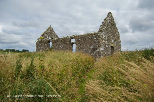
At Clonca in the far north of the Inishowen Peninsula in County Donegal you can find a small 17th century church. The church itself is rather plain, but it stands on the foundations of an earlier church that was part of an early-medieval monastic site founded by Saint Buodan. You can still see traces of this earlier monastery in the large lintel that has been reused in the church, and the remarkable two high crosses.

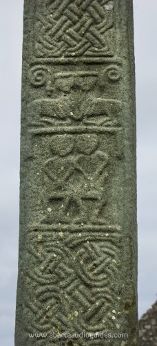
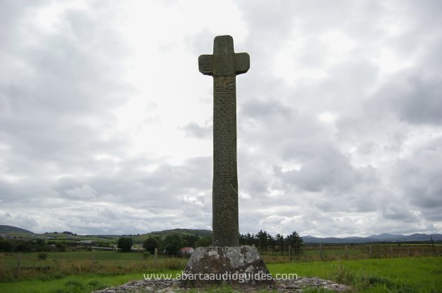
Only one of the high crosses still stands today, it is around 4m tall and probably dates to around the 11–12th century. However around three-quarters of the cross head appears to have been replaced.

Like most high crosses this example at Clonca displays biblical scenes like a depiction of the two apostles Peter and Paul, above them you can see strange looking beasts (maybe lions?), on the other side of the cross you can see the miracle of the loaves and fishes but much of the cross is taken up with intricate geometric patterns.

imageimage

The second cross is a little more difficult to find as it has long since collapsed, to find it walk through the field from the standing cross, walking near the fence back towards the road, keeping the hedge boundary of the field with the church in it on your right hand side. You’ll soon find the large fragments of the high cross lying on the ground. It  looks to have been a large ringed cross, decorated with curving shapes.

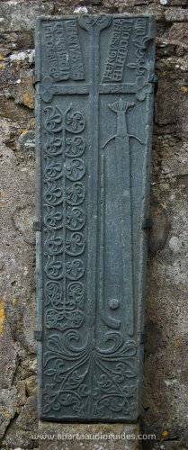
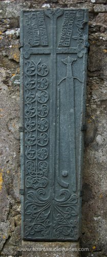
Back inside the church, you can see the rather ornately decorated fifteenth or sixteenth century graveslab. It has a large cross in the centre and to the right you can see a sword with a hurley stick and sliotar, one of the earliest depictions of a hurley and sliotar in Ireland!

image

The slab is inscribed with ‘Fergus Mak Allan Do Rini in Clach Sa Magnus Mec Orristin Ia Fo Trl Seo’ (Fergus MacAllan made this stone; Magnus Mac Orristin under this).

Clonca Church is certainly worth a visit, just for an excuse to drive around the beautiful Inishowen Peninsula. It is relatively straight forward to find, from Carndonagh take the R244 east for roughly 5km heading for Gorey. When you’re in Gorey take a left turn at the crossroads, drive through the next set of crossroads and you’ll see a sign pointing in a field just after the crossroads. There is space to pull the car in just before the site, and there is a solid path leading to the church from the road.

I hope you enjoy this article, it is part of a regular fortnightly series for TheJournal.ie, the articles are based on my blog. Take a look to see if we have covered any sites in your area.

If you would like to see daily updates with pictures and information on Irish heritage sites,  archaeology and history please consider following us on Facebook, Google+ or Twitter.

If you would like to support us please download an audioguide from abartaheritage.ie. There are currently 14 guides available with four free of charge and the rest costing just €1.99. They are full of original music and sound effects and are a fun and immersive way of hearing the story of some of Ireland’s most iconic heritage sites and places.

All images © abartaheritage.ie

Read more in the Hidden Ireland series>
How a shipwreck turned into an abbey>
Here’s what posh Irish toilets looked like 700 years ago>

Your Voice
Readers Comments
26
    Submit a report
    Please help us understand how this comment violates our community guidelines.
    Thank you for the feedback
    Your feedback has been sent to our team for review.