Advertisement

We need your help now

Support from readers like you keeps The Journal open.

You are visiting us because we have something you value. Independent, unbiased news that tells the truth. Advertising revenue goes some way to support our mission, but this year it has not been enough.

If you've seen value in our reporting, please contribute what you can, so we can continue to produce accurate and meaningful journalism. For everyone who needs it.
David O'Sullivan

Images captured during Californian aerial search for missing Corkman being analysed for blue backpack

The plane’s pilot said that the search was coordinated between aerial experts and local search volunteers.

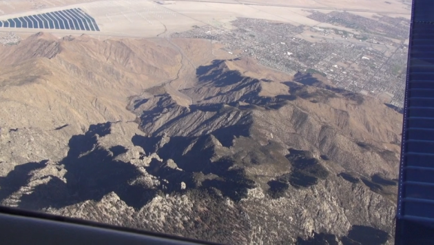
Oliver OGrady An aerial shot taken during the search. Gus Calderon Gus Calderon

AN AERIAL SEARCH has been conducted over a vast area in California, where Corkman David O’Sullivan made his last known contact with his family before going missing nine months ago.

The airborne operation was carried out after months of search efforts made on foot, and a refusal by US authorities to allow drones to search the area where he’s suspected to have gone missing.

Using camera equipment that’s made for aerial map surveying, the plane’s crew are analysing over 1,000 images collected during the search to try to find a trace of David. They’re also enhancing the images for the colour blue in the hope that it will pick up his blue backpack.

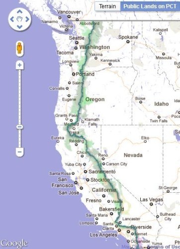
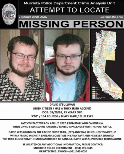
Last March, the 25-year-old set off on a hike across the Pacific Crest Trail, which runs from Mexico, along the west US coast up to Canada. He was due to meet a friend in Santa Barbara in early May, but never showed up.

His last known contact was made on 7 April, when he emailed his parents while based in Idyllwild in California, according to the Murrieta Police Department.

original (1) Murrieta Police Department Murrieta Police Department

On 15 December, eight months after his last known contact, a search effort was conducted over the areas where they think David may have gone missing.

The advantage of an aerial approach would that it would cover a large area in less time than a ground search would. After photos of the terrain were collected, software can be used to analyse the photos and find objects that the human eye can’t see.

The aerial search involved one plane, and was launched after a drone-manned search of the area was refused permission by local police.

The pilot of that plane Gus Calderon told TheJournal.ie that he became involved in the search effort after Gene Robinson, an expert in using drones for search and rescue operations, contacted him.

“Gene told me that the National Park Service was not granting permission for the drone operators to search for David. In the US there are new rules for drones and there are still many restricted areas, unfortunately.

Since Gene knows I have an airplane that is used for aerial surveys, he asked if I would be able to fly this mission.

A US search volunteer who acts as an intermediary for David’s family was consulted on how the flight should be coordinated.

After further discussions with his colleague Richard McCreight, the flight was planned for the first week in December.

Calderon says McCreight had worked at Nasa for over a decade and “has tremendous experience with aerial survey missions, so I was confident we could do it”.

Because of high winds and wildfires in southern California, the initial flight to be pushed back to the morning of 15 December at 11.15am.

One aircraft was involved in the search mission: a Beechcraft Bonanza A-36, modified to hold specialised cameras and sensors for aerial surveys, mapping, and photography.

The Pacific Crest Trail

Pacific Crest Trail in the Cascade Siskiyou National Monument Snow-covered Cascade Mountains along the Pacific Crest Trail near Ashland, Oregon. Bob Wick via PA Images Bob Wick via PA Images

The Pacific Crest Trail is 4,265km long, stretching from the Mexican border, twisting through the US states of California, Oregon and Washington, and up to Canada.

It crosses expansive deserts, 25 national forests, volcanic peaks and mountain ranges including the Sierra Nevada and Cascade mountain ranges.

There are numerous complications with searching over this type of terrain, Calderon says – with the main one being the different levels of elevation.

“Since the sun is lower in the sky during the winter, long shadows were cast in steep ravines and canyons. In general, we do most aerial surveys during the summer in order to illuminate as much ground as possible.”

At the time that David went missing, weather conditions were said to have turned snowy near the Idyllwild area.

original (5) US Forest Service US Forest Service

Calderon described how he, Robinson, and McCreight chose a search area to fly over that day in December.

“Once we had the search area, [we] used the coordinates to generate a series of parallel flight paths that were approximately 9 miles in length.

We have a computer and GPS onboard the aircraft that trigger the high-resolution camera at predefined locations on each flight path.
We collected over 1,250 images during the two-hour survey flight.

“The images are primarily being analysed by Gene Robinson and his team in Wimberly, Texas. Gene is using software that enhances the colour blue because he is searching for David’s blue backpack.”

This was the first time Calderon has conducted a search for a missing person; usually he uses the equipment for environmental monitoring, fire damage assessment, and general mapping.

“This search is essentially a ‘test case’ for this technology,” he said.

“While aerial surveys have been done for decades, the equipment was extremely expensive until recently. Advances in digital cameras and computers has made the acquisition of these systems affordable enough to install in light aircraft.

“Perhaps an entirely new application for this new equipment has been found, one that may benefit humanity in the future.”

There may be another aerial search of the area, but that will depend on what is found with the current set of images.

Speaking to RTÉ in August, Detective Sean Lawlor of the Murrieta Police Department said that David had left Ireland with hiking gear, a non-smart phone and a tablet.

Based on his conversations with family members, Lawlor said that David was not an expert hiker and had told his family he was intent on avoiding deep snow and ice.

Based on conditions he may have went off the trail [to] try to skirt around the Sierras, and could be further up north on the trail.

- With reporting from Daragh Brophy

Read: Missing Irish hiker ‘may have left California trail to avoid snowy conditions’

Read: Search underway for Irishman who went missing on a hike in California

Your Voice
Readers Comments
7
This is YOUR comments community. Stay civil, stay constructive, stay on topic. Please familiarise yourself with our comments policy here before taking part.
Leave a Comment
    Submit a report
    Please help us understand how this comment violates our community guidelines.
    Thank you for the feedback
    Your feedback has been sent to our team for review.

    Leave a commentcancel