Advertisement

We need your help now

Support from readers like you keeps The Journal open.

You are visiting us because we have something you value. Independent, unbiased news that tells the truth. Advertising revenue goes some way to support our mission, but this year it has not been enough.

If you've seen value in our reporting, please contribute what you can, so we can continue to produce accurate and meaningful journalism. For everyone who needs it.
dublin on move

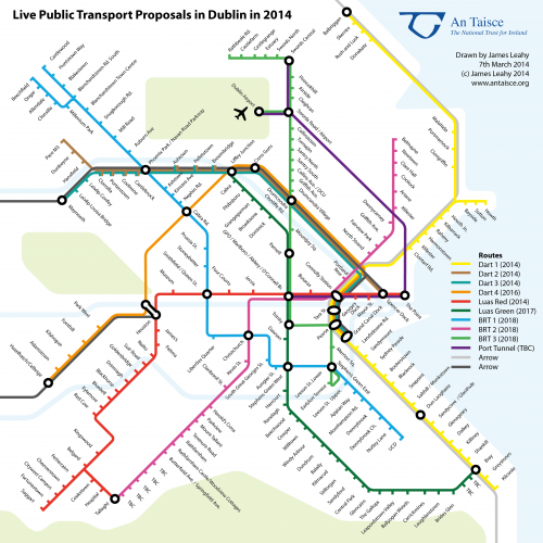
London Tube-style map shows how Dublin public transport will link up

It’ll be pretty if it works out, we’ll give them that.

imageIf looking for highest-res version, please click here.

THIS IS HOW authorities see public transport integrating in the greater Dublin area in the near future.

An Taisce have published this London Tube-style representation of what tranport links will look like when Luas, QBCs (Quality Bus Corridors) and other transport projects are completed.

James Leahy, Honorary Secretary of An Taisce, said:

If the plan works, as it has elsewhere, we will have a system that could be extended to cover the whole city to serve all. This can never happen with rail projects alone, in our sprawling low-density city.

There is currently a public consultation on the draft Integrated Implementation Plan 2013 -2018 for the Greater Dublin Area. You can read that document here.

The implementation plan includes three Bus Rapid Transit routes. The NTA is now carrying out a public consultation on these three routes with a deadline of 14 March, next Friday. You can see that here.

Planning a trip on public transport? There’s an app for that>

Your Voice
Readers Comments
68
    Submit a report
    Please help us understand how this comment violates our community guidelines.
    Thank you for the feedback
    Your feedback has been sent to our team for review.