Advertisement

We need your help now

Support from readers like you keeps The Journal open.

You are visiting us because we have something you value. Independent, unbiased news that tells the truth. Advertising revenue goes some way to support our mission, but this year it has not been enough.

If you've seen value in our reporting, please contribute what you can, so we can continue to produce accurate and meaningful journalism. For everyone who needs it.

Vanishing Past

Coastal erosion will wipe out many ancient seaside sites and monuments

Escalating storms and extreme weather caused by climate change will increase coastal erosion with many Irish landmarks unable to be saved, experts say.

IRELAND’S ESCALATING EROSION rates mean that many historic monuments and heritage sites cannot be saved from falling into the sea.

Linked to an increase in fierce storms and extreme weather battering the coast, the rising rates of erosion will only weaken already vulnerable landmarks – some beyond repair.

Noteworthy can reveal that in a bid to keep on top of increasing climate threats to monuments, the government is developing a ‘hazard map’ of the most at-risk sites.

The nationwide assessment will see hundreds of protected structures colour coded alongside vulnerability and the level of threat faced.

The mapping, confirmed by the Office of Public Works (OPW), is expected to be finished and launched next year.

However, the new grading system won’t apply to tens of thousands of ancient buildings and landmarks, most of which are located on private land.

That includes Co Sligo’s Staad Abbey, a medieval church which locals fear will soon be lost to the sea.

Sites such as Co Wexford’s crumbling Glasscarraig motte – one of the first Norman fortifications built in Ireland – will also not fall under the scope of the hazard mapping despite actively being eroded by the sea.

Experts tell Noteworthy that ongoing damage caused by climate issues will mount unsustainable pressure on government resources.

They say this will lead to more “managed loss” strategies being applied to disappearing history, instead of saving it.

The “preservation by record” approach would see sites excavated and documented for local communities, visitors and future generations.

“We just have to accept that there are certain coastal areas we’re not going to be able to defend,” Ian Lumley, An Taisce’s Heritage Officer, told Noteworthy.

“Coastal erosion is a continuous process but climate change is now clearly exacerbating that.”

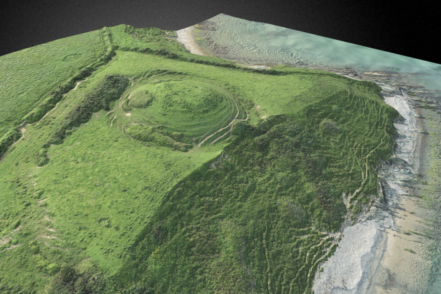
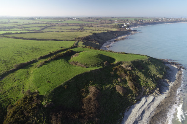
dcim103mediadji_0826-jpg Aerial image of Glasscarraig motte and bailey in Co Wexford. CHERISH / Discovery Project CHERISH / Discovery Project / Discovery Project

Noteworthy, the crowdfunded community-led investigative platform from The Journal, supports independent and impactful public interest journalism.

No data recorded on threats

Despite there being almost 140,000 recorded archaeological sites and monuments in Ireland, no baseline data exists on the threats posed to them by climate change.

Of those, 550 are architectural conservation areas (ACAs) and 44,000 are recorded as protected structures, the vast majority of which are in private ownership.

There are currently almost 1,000 national monuments protected under the National Monuments Act which enforces the preservation of structures of national importance.

An ACA is a place, area, group of structures, or townscape that is of special interest in terms of architecture, history, archaeology or another specific factor. Whereas a protected structure is a building, or part of a building, that a planning authority considers to be of special interest for similar reasons.

Data is also poor when it comes to sites located on the coast and impacted by erosion.

Martello Towers, castles, historic houses and promontory forts are among the gems of architecture which link Ireland to its rich past.

Government maps used to predict the risk of coastal collapse to such structures are also inaccurate.

According to a Built & Archaeological Heritage Climate Change Adaptation Plan, published in 2019, maps showing predicted rates of erosion by 2050 “might be an overly optimistic view” as the estimates failed to take climate change into account.

The OPW commissioned erosion forecast is still being used on government websites.

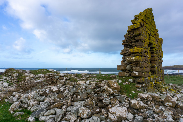
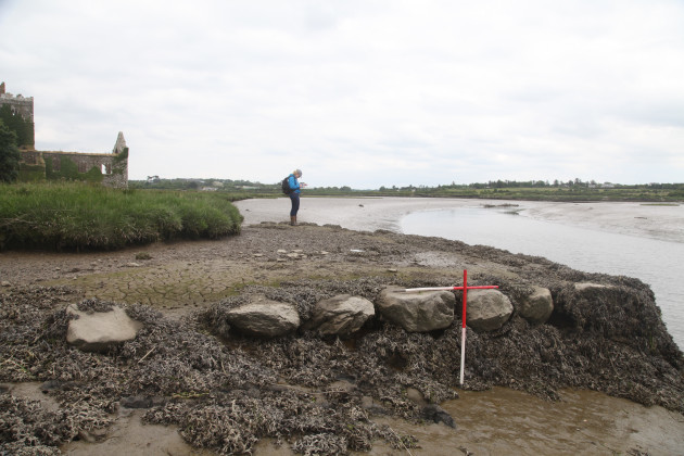
Staad1 Medieval site Staad Abbey in Co Sligo which is at risk of falling into the sea due to coastal erosion. Maria Delaney / Noteworthy Maria Delaney / Noteworthy / Noteworthy

Communities recording the loss

The threat of losing history is felt even more profoundly in the many smaller, more remote coastal communities on the island.

In a field just off the Atlantic coast in Co Sligo, sits the ruins of Staad Abbey.

For years the medieval church, where survivors of the Spanish Armada are reported to have sought refuge in 1588, has been edging closer and closer to the sea.

Despite its dilapidated state and remote rural location, the church still draws in visitors from all over the world and locals are desperate to save it.

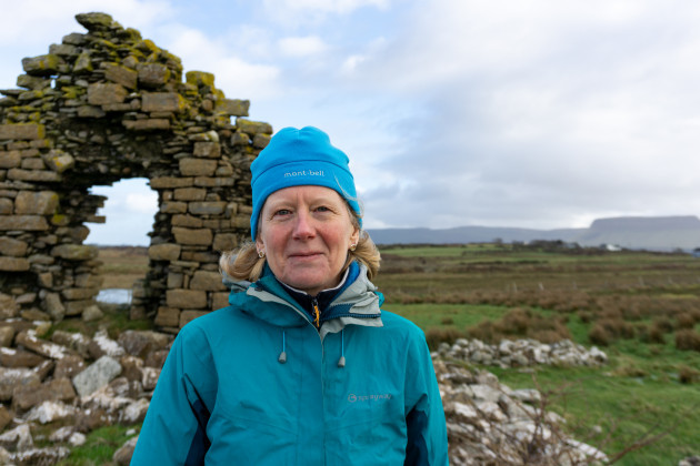
Its significance is not lost on Dr Fiona Beglane, a zooarchaeologist and lecturer at Sligo’s Atlantic Technological University.

Along with archaeologist Jerry O’Sullivan, Beglane carried out a dig at the site which revealed evidence of a 4,000 year-old Bronze Age platform and preserved wooden posts dating back 3,500 years.

The study also outlined the risk of Staad completely disappearing from the area.

“The rates [of erosion are] definitely increasing,” she told Noteworthy. “We know, for example, that back in the 1830s there was about 19 metres between the corner of the church and the sea itself and now we’re down to about 3.1 metres.”

Again, extreme weather and increasing storms have heightened the vulnerability of the church with fears that some day, locals will wake up and it will be completely lost.

“The previous landowner of the site, said that in one night, he woke up in the morning after a huge storm, and he lost what he described as half a field in the single night,” Beglane said.

Locals feel very, very strongly about the place and are very keen to look after it, maintain it and to know that it’s there.

“The Grange Armada Association Group, they’re instrumental in a lot of the heritage related things in the area and Staad to them is very important.”

Stephen Herron, whose father owns the private land on which Staad Abbey sits, would love to see the area preserved.

Although battling with nature is tough, Herron said that thoughtless visitors have also posed a risk to the already vulnerable ancient abbey.

He told Noteworthy that those entering the ruins have previously moved stones, endangering both themselves and what’s left of the church.

As a result, he’s been forced to erect signage to ask people to not enter the field.

“I’m just so proud of the fact that down through two generations of people, not even my mother, but older neighbours, who are dead now, they just respected it,” he said.

“And if they didn’t, there would be no gable there.”

He said he would like to see more support from the local authorities in both preserving and securing Staad.

This is history, this is all that is left.

Sligo County Council said it is aware of Staad Abbey’s vulnerability but has “no remit for the care of archaeological monuments on private lands”.

However, the council added that under the Community Monuments Fund, grants are available to private landowners and local communities to “undertake conservation works, conservation reports and to improve access and interpretation of monuments”.

FionaBeglane Zooarchaeologist Dr Fiona Beglane at the site of the historic Stand Abbey in Co Sligo. Maria Delaney / Noteworthy Maria Delaney / Noteworthy / Noteworthy

Baseline data for some heritage sites has begun

In Co Wexford, where over 75% of the coast is vulnerable to erosion, sits Glasscarraig motte and bailey.

The 12th century site is believed to be one of the first Norman fortifications in Ireland, with links to King of Leinster Diarmuid Mac Murchada.

A section of the landmark has already been lost to the sea with ongoing coastal damage being reported.

It was recently one of 17 sites in Ireland investigated as part of a EU funded project on corrosive coast risks.

CHERISH – which stands for climate, heritage and environments of reefs, islands and headlands – carried out the six year study of maritime cultural heritage which stretched across to Wales.

Headed up by archaeologists from the Discovery Programme and the Geological Survey of Ireland (GSI), the project ended in June last year.

Ted Pollard, maritime and culture archaeologist at the Discovery Programme, carried out work at the north Wexford site, as well as excavation work at another disappearing promontory fort in Co Kerry.

Coastal erosion is very serious, he said. “These promonitories are just being attacked, at least on three sides, by the storms and the sea.”

There are around 400 promontory forts in Ireland, with most dating back to the Iron Age. Due to their locations on the coast, many are at high risk of being completely lost.

In May 2021, Pollard and the CHERISH team were granted permission to excavate the ancient Ferriter’s Castle and Promontory Fort in Co Kerry, which had suffered approximately 20 metres of erosion.

The 10-day dig unearthed earlier Bronze Age material, as well as post holes, a strut trench, and charcoal fragments at a depth of 1.2 metres.

Glascarrig Motte & Bailey - Wexford - 3D Model A 3D interactive model of Glasscarraig motte and bailey created by the CHERISH project. CHERISH / Discovery Project CHERISH / Discovery Project / Discovery Project

Loss of history sites is ‘inevitable’

According to Anthony Corns, project manager with the Discovery Programme, the CHERISH project revealed a surprising number of heritage sites that are under threat in Ireland.

“We never really quantified it,” he said. “Not all of them can be looked at with the same level of intensity that we looked at a site so there will have to be a prioritisation above us – in the government – to say which sites should resources go into to look after.”

Following the long-term project, the team is currently working on a national hazard map for monuments under climate change threat in Ireland.

Carried out alongside the National Monument Service (NMS), national monuments will be mapped with a colour code score on their vulnerability and potential risks.

We all take for granted the environment we live in.

When “the history around us” starts going, Corns felt “it’s just like somebody vandalised your town, and your heritage and your connection with the past.

“That’s why sometimes cultural heritage is like a canary in the coal mine, and it focuses people’s minds on things like climate change.”

Corns said that although difficult for many communities, loss of heritage and history was “inevitable” as “the resources for every site aren’t going to be there”.

“One of the things you have to do with the idea of climate change is teach people to understand that loss is inevitable, and how to live with loss,” he said.

“It’s kind of like therapy, a grieving process.”

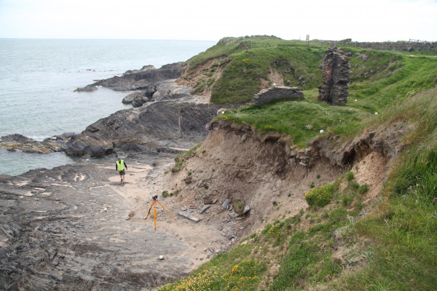
Wexford CHERISH archaeologists at the old coastguard station at Kilmichael Co Wexford using laser scanning to assess erosion damage. CHERISH / Discovery Project CHERISH / Discovery Project / Discovery Project

Managing future loss of history

The Department of Housing, Local Government and Heritage said that as the “trend of impacts” on vulnerable coasts increases, the issue of managing future loss “must be addressed”.

A spokesperson said important baseline assessments, such as those carried out by CHERISH, have helped develop methodologies in best practice at managing and recording under threat sites.

“Where called for, the Department engages services to scientifically record sites impacted on by extreme weather and its resultant impacts, such as coastal erosion and it is expected that such services will be engaged regularly in the future,” a department spokesperson told Noteworthy.

“On monitoring of erosion in general, various tools are being utilised and developed further, including OPW LiDar datasets to monitor change,” they added.

The department said heritage grant schemes such as the Community Monuments Fund had also been “increased significantly” over recent years with “specific streams of support” to protect heritage sites against the impacts of extreme weather brought about by climate change.

The development of climate hazard risk mapping will also help identify areas and sites of vulnerability, the department said.

Wexford 2 A CHERISH archaeologist recording the eroding quay and friary at Clonmines Co Wexford. CHERISH / Discovery Project CHERISH / Discovery Project / Discovery Project

Erosion threatening the past and present

Jim Moore, a Wexford County Council representative, wants a national coastal erosion action plan to deal with erosion.

Over the last 10 years, Moore has seen parts of the area rapidly fall away, endangering homes, farmland and roads with recent erosion rates taking on “a new lease of life”.

“Now, we have a climate action plan that deals with the weather situation and rising sea levels, which poses another risk” he told Noteworthy. “But all the conversation has been about is coastal protection.

“It is shocking that as an island nation, on the outskirts of mainland Europe, exposed to the Atlantic, there is no structure in place to monitor and deliver the data that we need for an action plan. It is quite unbelievable.”

In Sea View, a residential area close to Kilmore Quay, locals are now using the fourth replacement of the one and only road into their homes. Moore said:

How can we protect our heritage when we can’t even protect people’s homes?

A recent report obtained by Noteworthy paints a worrying picture of the levels of climate threat to coastal areas.

The Climate Action Regional Offices (CARO) assessment found that between 2017 and 2022, there was a 173% rise in the number of properties identified by local authorities under threat from coastal erosion.

The 2022 ‘Analysis of Coastal Erosion & Coastal Change Survey’ recorded an 89% increase in the number of roads councils deemed to be in danger by councils from rapidly changing shorelines.

However, the report only received responses from around half of the country’s 19 coastal authorities, describing the most recent rising erosion rates as “likely an underestimate”.

The CARO report also estimates that by 2050, almost 4,500 properties in eight council areas will be at risk from falling into the sea – an increase of over 2,000 from the current situation.

Of the 10 councils that completed assessments of at-risk roads in their areas, a total of 570.5 km was deemed as under threat from coastal collapse – a combined potential road loss longer than the length of Ireland.

This, the report states, is an increase of 265 km since 2017.

Of the 19 councils, 16 responded that coastal erosion was worsening in their area.

The report stated: “This shows the huge challenge currently facing coastal local authorities which will only escalate into the future with the predicted increase and frequency in storm surges and sea-level rise.”

Read how vandalising is also causing significant damage to monuments >>

Have a listen to The Explainer x Noteworthy podcast on our findings


Are Ireland’s historic sites at risk of disappearing?

By Patricia Devlin of Noteworthy

Noteworthy is the crowdfunded investigative journalism platform from The Journal. This project was proposed and funded by our readers alongside significant support from our investigative fund

What’s next? We want to expose if councils are accounting for sea-level rise in coastal planning decisions. Help fund this work >>

Your Voice
Readers Comments
67
This is YOUR comments community. Stay civil, stay constructive, stay on topic. Please familiarise yourself with our comments policy here before taking part.
Leave a Comment
    Submit a report
    Please help us understand how this comment violates our community guidelines.
    Thank you for the feedback
    Your feedback has been sent to our team for review.

    Leave a commentcancel