Readers like you keep news free for everyone.
More than 5,000 readers have already pitched in to keep free access to The Journal.
For the price of one cup of coffee each week you can help keep paywalls away.
Readers like you keep news free for everyone.
More than 5,000 readers have already pitched in to keep free access to The Journal.
For the price of one cup of coffee each week you can help keep paywalls away.
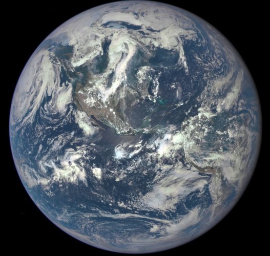
NASA HAS RELEASED an image of what the earth looks like from one million miles away.
The incredible photo shows the Deep Space Climate Observatory (DSCOVR) satellite’s first view of the entire sunlit side of earth.
It is the first full photo of earth taken in 43 years. The last one was taken in 1972 on Appollo 17, as reported by Quartz.
The colour image was taken on 6 July by Nasa’s Earth Polychromatic Imaging Camera (Epic), a four megapixel CCD camera and telescope. It shows North and Central America.
The image was generated by combining three separate images to create a photographic-quality image.
The central turquoise areas are shallow seas around the Caribbean islands. The image shows the effects of sunlight scattered by air molecules.
Once EPIC begins regular data acquisition, it will provide a daily series of earth images allowing for the first-time study of daily variations over the entire globe. These images, available 12 to 36 hours after they are acquired, will be posted to a dedicated website by September 2015.
The primary objective of DSCOVR, a partnership between Nasa, the National Oceanic and Atmospheric Administration (NOAA) and the US Air Force, is to maintain America’s real-time solar wind monitoring capabilities which are critical to the accuracy and lead time of space weather alerts and forecasts from NOAA.
To embed this post, copy the code below on your site