Sign in. It’s quick, free and it’s up to you.
An account is an optional way to support the work we do. Find out more.
Sign in. It’s quick, free and it’s up to you.
An account is an optional way to support the work we do. Find out more.
THE CITY OF Derry is fast becoming one of the most vibrant and successful places for a weekend break, and has been deservedly awarded the first UK City of Culture.
The city itself is steeped in history, and you could easily spend a day going around the City Walls, and visiting the numerous historic buildings and cathedrals (I’ll certainly be covering more on the city itself in forthcoming articles).
As great as the city is, its relatively unexplored hinterland offers even more for visitors to the region, so be sure to spend an extra day or two exploring the beautiful Faughan Valley and surrounding area.
The River Faughan rises in the Northern Sperrins and gently flows into Lough Foyle.
It is popular with anglers, and a glance at the Ordnance Survey Discoverer Map 7, shows the slopes around the river are crowded with archaeological sites. Here in the peaceful Faughan Valley just outside of Derry you can see a whole prehistoric Bronze Age landscape with numerous monuments scattered throughout the region.
Bronze Age Ireland saw the construction of new types of stone monuments in the landscape, the large court tombs and passage tombs of the Neolithic gave way to the smaller wedge tombs, cist burials, stone circles, rows, alignments and solitary standing stones.
The first of these that we visited were these prominent standing stones at Clagan
There are three standing stones visible here though only one still stands vertical, originally they probably formed a small stone row. They seem to be put to good use by the bullocks who were enjoying a good scratch on them when we arrived. There are beautiful views down the Faughan Valley from the hill on where the stones stand, and this site is well worth a look if you’re in the area.
To find the standing stones, take the B74 Glenshane Road from Claudy, then take the second left onto the Clagan Road and you’ll see the stones in a field around 400m south-east of Clagan Bridge. Park safely on the road and as there are livestock in the fields surrounding the stones please be sure to close all gates behind you.
At Ballygroll you can find a quite remarkable collection of prehistoric monuments, all clustered together on a sandy ridge at Slievegore Hill. Much of the site is covered by bog, but excavations in the late 1970s revealed part of a large prehistoric complex. The identified remains include a court tomb, two wedge tombs, a circular stone cairn, a barrow, two stone circles, cist burials and prehistoric field walls.
The earliest monument discovered at Ballygroll is a Neolithic court tomb (this type of monument generally dates from around 4000–2500 BC). The capstone of the tomb appears to have faint cup marks as decoration.
The wedge tombs (see the picture above) are from the end of the Neolithic period or Early Bronze Age (around 2500–2000 BC) and the stone circles probably date to the Early Bronze Age (2500–1500 BC). Archaeologists dated the barrow to the Late Bronze Age, all of this shows that this region on the hills around the fertile Faughan Valley was an important and thriving place in prehistoric Ireland for over three millennia.
Ballygroll was likely to be just the tip of the iceberg, the whole flanks of the Loughermore Mountain was recorded to have large numbers of prehistoric monuments during the mapping in the 1830s, but apart from Ballygroll much has been lost due to agricultural land reclamation over the years.
The bog that surrounds the features and the plantlife that partially obscures them are in themselves interesting and worth a visit, with mosses, lichens, flowers and insects giving you an accessible and fun introduction to Irish bogs.
Sometimes the plantlife can make finding the monuments something of a challenge, and it’s probably best visited on a dry day after a frost rather than in the height of summer when the grasses are at their highest.
We got to Ballygroll by driving on a minor road north from Ervey Crossroads to Highmoor.
The site was signposted. There was no parking at Ballygroll but we parked on the laneway leading down to the site. You’ll find a large interpretation panel with a map of the features, it’s worth taking a quick snap of this on your camera to allow you to reference back and keep your bearings on this expansive site.
While you are in the area of Ballygroll pay a visit to Ness Woods to see the highest waterfall in Northern Ireland.
The park covers 55 hectares of mixed woods and is a beautiful place to stop for a picnic. The NIEA have recently opened a visitor centre with a carpark and well formed trails making it an accessible and beautiful place to visit. We explored these areas with a great guide, Martin from Landscape and Countryside Tours. Click here for more info.
Also in the area you can find Ashbrook House. Situated in 30 acres of mature parkland, Ashbrook House has been the home of the Ash family since the 1590s. We were given a great tour by Melanie, whose family first built the house in the late-sixteenth century.
The house is a two-storey, bow fronted house and the oldest part of the structure is thought to date to the late sixteenth century, you can notice the older parts of the structure by the low ceilings and much thicker walls.
Entering through the grand entrance hallway you’ll quickly notice that the house is steeped in the family’s history and everywhere you look there are portraits, artefacts and mementos that tell a thousand stories and tales of the Beresford-Ash family. Melanie told us some of these tales and it was a fun and fascinating journey through her family’s history, it is no exaggeration to say that you could easily spend days just looking at all the different pieces of furniture, items or paintings that fill the house, it is an absolute feast for the eyes.
We had the opportunity to see numerous rooms, each with its own character and stories – it was a truly fascinating way to spend a morning. If you are visiting Derry then do make an appointment to visit Ashbrook, this beautiful historical house makes a lovely counterbalance to the thriving and bustling city: I highly recommend a visit!
You can find out more about Ashbrook and book a tour by visiting their website. While you are visiting Ashbrook do drop in to the lovely Beech Hill Country House for a walk around their beautiful grounds to discover where the US Marines were based during WWII and you can enjoy some gorgeous food!
Evidence of the plantation history of the region can be found at Brackfield Bawn around 4km north of Claudy and just off the main A6 road.
The Bawn was constructed in around 1611 by Sir Edward Doddington on land granted to the Skinners Company. The Bawn commands the east – west route to Derry and with its formidable defences it would have provided a safe refuge for nearby settlers during times of conflict.
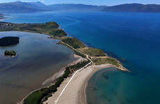
Around 8km northwest of Derry – in Co Donegal – you can find The Grianán of Ailech, one of the most iconic sites of northwest Ireland itself. The entire site itself is enormous, with large outer earthworks circling Greenan Mountain. The site was said to have been the residence of the powerful Kings of Ailech, the Uí Néill dynasty.
In the first few centuries AD the Uí Néill controlled vast swathes of territory in the northern half of the island of Ireland. However as their power began to wane they became locked in a bitter dynastic war with the Kings of Munster. The Grianán was recorded in the Annals as being destroyed in AD 676, and then more thoroughly in 1101. The destruction was recorded in detail in the pages of the Annals of the Four Masters.
It recounts that the King of Munster, Muircheartach Ua Briain (grandson of the famous Brian Boru), led his army deep into the territory of the Uí Néill’s in Inishowen and burned many churches and forts. He demolished the Grianán of Ailech in retaliation for the burning of the Munster capital Ceanncoradh (Kincora in County Clare) which had been burned by the allies of the Uí Néill some time before. The Munster King Muircheartach had each man in his army carry away a stone from the destroyed fort, forever denying it to the Uí Néills.
The site was heavily reconstructed in the nineteenth century, so we will never know its original form. Despite this, it is still one of the most rewarding sites to visit in Ireland. The name Grianán roughly translates to Palace of the Sun, unfortunately the day we visited was heavily overcast with showers, though even the low cloud couldn’t obscure the quite magnificent views over the Inishowen Peninsula, Lough Swilly, and Lough Foyle. The site absolutely dominates the skyline from a great distance.
Entering the central cashel you pass through the massively thick drystone walls that tower above you. Stone steps lead to the top of the walls allowing you to look upon the stunning landscape that surrounds you. It is a fantastic experience. Just outside of the fort you can also find a cairn of uncertain date and a small holy well.
The site is under the auspices of the Office of Public Works, however apart from a good road and a large carpark there are no other facilities at the site. The Grianán of Ailech is well signposted from the N13 between Derry and Letterkenny.
For more information about the lovely Faughan Valley and to find accommodation please click here. If you find yourself suffering from history overload there are lots of other great activities you can do in the area, we particularly enjoyed a horseback trek along the Faughan with Ardmore Stables, and a fun spin with Cutting Edge Helicopters. Check the website above for information on things to do.
I hope you enjoy this article, it is part of a regular fortnightly series for The Journal, the articles are based on my blog. Take a look to see if we have covered any sites in your area. In our next article for TheJournal.ie we’ll be looking at sites in counties Kilkenny, Donegal and Fermanagh.
If you would like to see daily updates with pictures and information on Irish heritage sites, archaeology and history please consider following us on Facebook, Google+ or Twitter.
If you would like to support us please download an audioguide from abartaheritage.ie. There are currently 14 guides available with four free of charge and the rest costing just €1.99. They are full of original music and sound effects and are a fun and immersive way of hearing the story of some of Ireland’s most iconic heritage sites and places.
They are as enjoyable at the site as they are from the comfort of your favourite armchair at home. Why not try our guide to Viking and Medieval Dublin to hear the story of the birth of a city? Or try our free audioguide to the wonderful heritage town of Kells.

To embed this post, copy the code below on your site


have your say