Advertisement

We need your help now

Support from readers like you keeps The Journal open.

You are visiting us because we have something you value. Independent, unbiased news that tells the truth. Advertising revenue goes some way to support our mission, but this year it has not been enough.

If you've seen value in our reporting, please contribute what you can, so we can continue to produce accurate and meaningful journalism. For everyone who needs it.
mythical ireland

Photos: Previously unknown monuments unearthed using Google Earth imagery

Monuments dating from several centuries to several millennia ago are visible in the imagery taken in June 2018.

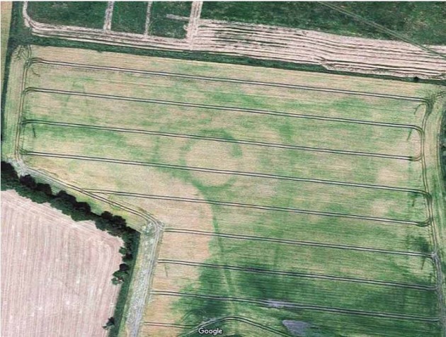
mythical 1 A recorded ringfort at Donadea, Kildare Google Google

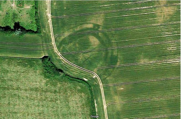
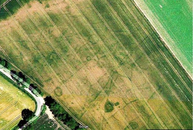
A NUMBER OF archaeological monuments have been revealed in tillage fields by Google Maps imagery taken during the drought last summer, the group Mythical Ireland has said.

These sites include previously unknown features ranging in dates from several centuries ago to several millennia ago.

Most of the new monuments are in parts of Meath, Dublin, Kildare and Carlow with the images being taken last June when the country was basking in a heatwave.

mythical 2 File system and possible ring barrows at Tippeenan Upper, Kildare Google Google

Anthony Murphy, founder of Mythical Ireland, said: “In many cases, these monuments will have no surface trace, so the farmers and landowners will be unlikely to know they even exist.”

Some of the monuments are Bronze Age barrows that could be up to 4,000 years old, with Iron Age ringforts and medieval enclosures also revealed by the maps. 

“Some are small ring-ditches, maybe 20m or 30m in diameter, but there are some truly enormous structures like ringforts and enclosures, in some cases measuring 100m in diameter and more. The largest structure visible in the Google imagery is in Co. Dublin and measures a staggering 350m wide,” Murphy said.

It’s an insight into agriculture in previous times. People have been farming the land in Ireland for around 6,000 years. The evidence of their settlements, and indeed their farms and of course their burial grounds, is literally everywhere.

They became in visible in the summer during the drought conditions when crops were starved of moisture in tillage fields.

mythical 3 Previously unrecorded circular enclosure/ringfort at Rathangan Demsne, Kildare Google Google

“The ditch features retain whatever trace moisture is in the ground a little more effectively than the surrounding soil, and so the crops growing out of the archaeological features tend to be a tiny bit greener and healthier” he said. “From the air, what you get is a contrast between the healthier and less healthy crops, revealing the shape and size of the structures beneath the surface. It’s fascinating.”

Murphy added that these discoveries will be reported to the National Monuments Service and be added to their database of archaeological sites and monuments.

He discovered a large circular enclosure near Newgrange last summer, after spotting the site when flying drones. 

TheJournal.ie / YouTube

Your Voice
Readers Comments
11
This is YOUR comments community. Stay civil, stay constructive, stay on topic. Please familiarise yourself with our comments policy here before taking part.
Leave a Comment
    Submit a report
    Please help us understand how this comment violates our community guidelines.
    Thank you for the feedback
    Your feedback has been sent to our team for review.

    Leave a commentcancel