Sign in. It’s quick, free and it’s up to you.
An account is an optional way to support the work we do. Find out more.
Sign in. It’s quick, free and it’s up to you.
An account is an optional way to support the work we do. Find out more.
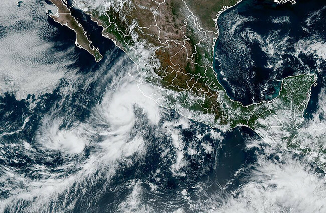
POWERFUL STORM ORLENE has been upgraded to a Category 4 hurricane as it nears Mexico’s Pacific coast, where it is expected to make landfall tomorrow night, the US National Hurricane Center (NHC) said.
“Extremely dangerous Category 4 Hurricane Orlene continues northward,” the NHC said in an advisory this morning, warning of “significant wind, storm surge and rainfall” in the Islas Marias and southwest Mexico.
At the time of the advisory the hurricane was 105 miles (170 kilometers) southwest of Cabo Corrientes in the western state of Jalisco.
Orlene comes after Hurricane Ian wreaked havoc on Florida and the Carolinas, with hundreds of thousands of people still sweltering without power.
Florida, with nearly four dozen reported dead, was hit hardest by the Category 4 hurricane, one of the strongest to make landfall in the United States.
The NHC forecast predicted that Orlene could gather further strength early on Sunday, but would then start gradually weakening until landfall.
Mexico’s National Water Commission also predicted that the storm would be a Category 1 or 2 hurricane by the time it moves onto land on Tuesday.
Mexico is hit by tropical cyclones every year on both its Pacific and Atlantic coasts, usually between May and November.
In October 1997, Hurricane Paulina hit Mexico’s Pacific coast as a Category 4 storm, leaving more than 200 dead.

To embed this post, copy the code below on your site


have your say