Sign in. It’s quick, free and it’s up to you.
An account is an optional way to support the work we do. Find out more.
Sign in. It’s quick, free and it’s up to you.
An account is an optional way to support the work we do. Find out more.
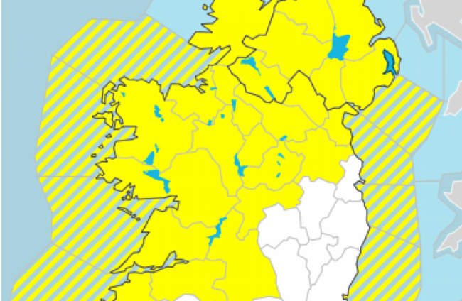
A STATUS YELLOW thunderstorm and rain warning has been issued for 23 counties.
Met Éireann is forecasting thundery spells of rain for Connacht, Ulster, north Leinster and north Munster.
The national forecaster said this will lead to localised flooding and hazardous driving conditions – particularly in Kerry, Limerick, Clare and Tipperary where longer spells of rain are expected.
The warning kicks in at 9am and will remain in place until 9am tomorrow.
The best of the drier spells will be across the south and southeast, according to the forecaster.
Outbreaks of thundery rain are to persist overnight, heaviest and most frequent across Atlantic counties, with lowest temperatures of 12 to 15 degrees.
Thundery outbreaks of rain today will bring hazardous driving conditions and spot flooding. ⛈️🚗
— Met Éireann (@MetEireann) August 6, 2021
Driest across the south and southeast early on.
Highs of 15 to 19C
More detail ➡️https://t.co/9gKN6SVok4 pic.twitter.com/cazOW5vHQV
Yellow warnings are not unusual. Met Éireann uses them to make people aware of weather that does not pose a threat to the general population, but is potentially dangerous on a localised scale.
Tomorrow will see blustery outbreaks of rain with further spot flooding and possible thunderstorms. The southwest may see brighter conditions with just isolated showers while Saturday night will see showers mostly confined to Ulster and western counties into Sunday.
Showers will be heaviest and most frequent over the northern half of the country on Sunday ahead of next week. Highest temperatures of 16 to 20 degrees, with the odd sunny spell in parts.

To embed this post, copy the code below on your site












have your say