Sign in. It’s quick, free and it’s up to you.
An account is an optional way to support the work we do. Find out more.
Sign in. It’s quick, free and it’s up to you.
An account is an optional way to support the work we do. Find out more.

FOR THE FIRST TIME in four decades, army engineers in the United States have opened floodgates on the Mississippi, Louisiana, in an attempt to save cities dotted along the river.
The move is expected to engulf up to 3,000–sq miles of land, reports the BBC, but is hoped to ease pressure on Baton Rouge and New Orleans.
Over the next few days, water spewing through a Mississippi River floodgate will crawl through the swamps of Louisiana’s Cajun country, chasing people and animals to higher ground while leaving much of the land under 10 to 20 feet of brown muck.
The floodgate was opened Saturday for the first time in nearly forty years, shooting out like a waterfall, spraying 6 feet into the air. Fish jumped or were hurled through the white froth and what was dry land soon turned into a raging channel.
The water will flow 20 miles south into the Atchafalaya Basin, and from there it will roll on to Morgan City, an oil-and-seafood hub and a community of 12,000.
The opening of the spillway will divert water from Baton Rouge and New Orleans, and the numerous oil refineries and chemical plants along the lower reaches of the Mississippi. Shifting the water away from the cities will also ease the strain on levees and blunts the potential for flooding in New Orleans that could have been much worse than Hurricane Katrina.
The Morganza spillway is part of a system of locks and levees built after the great flood of 1927, which killed hundreds and left many more without homes. When the Morganza opened, it was the first time three flood-control systems have been unlocked at the same time along the Mississippi River, a sign of just how historic the current flooding has been.
Earlier this month, the corps intentionally blew holes into a levee in Missouri to employ a similar cities-first strategy, and it also opened a spillway northwest of New Orleans about a week ago.
Snowmelt and heavy rain swelled the Mississippi, and the river has peaked at levels not seen in 70 years.
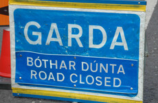
In Krotz Springs, Louisiana, one of the towns in the Atchafalaya River basin bracing for floodwaters, phones at the local police department rang nonstop as residents sought information on road closings and evacuation routes.
Like so many other residents downstream of the Morganza, Monita Reed, 56, recalled the last time it was opened in 1973.
“We could sit in our yard and hear the water,” she said as workers constructed a makeshift levee of sandbags and soil-filled mesh boxes in hopes of protecting the 240 homes in her subdivision.
About 25,000 people and 11,000 structures could be affected by the oncoming water, and some people living in the threatened stretch of countryside — an area known for fish camps and a drawling French dialect — have already fled. Reed’s family packed her furniture, clothing and pictures in a rental truck and a relative’s trailer.
“I’m just going to move and store my stuff. I’m going to stay here until they tell us to leave,” she said. “Hopefully, we won’t see much water and then I can move back in. ”
Additional reporting by AP

To embed this post, copy the code below on your site


have your say