Sign in. It’s quick, free and it’s up to you.
An account is an optional way to support the work we do. Find out more.
Sign in. It’s quick, free and it’s up to you.
An account is an optional way to support the work we do. Find out more.
Updated at 1.20pm
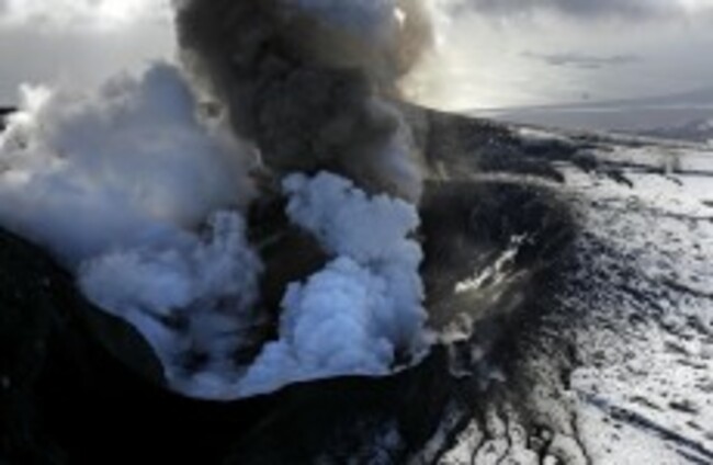
AUTHORITIES IN ICELAND have evacuated tourists and hikers from an area close to the Bardarbunga volcano due to seismic activity recorded at the site since Saturday.
Iceland’s Civil Protection Authority told public broadcaster RUV that it had finished the evacuation from around the Bardarbunga volcano but that further air patrols would be carried out to ensure no-one remained.
The area is uninhabited, with only trekking cabins and campsites used by tourists and hunters in the summer months.
“We of course don’t know about all hikers and such, but we are going to look over the area with the aid of the Coast Guard and after that we should be very certain that no-one is in the area,” Vidir Reynisson at the Civil Protection Authority (CPA) told RUV.
The authority said the volcano was stable today, but still in danger of erupting.
Up to 300 people are believed to have been evacuated from the area around the volcano, and the country’s emergency services have been placed on ‘alert’.
Sitting on one of the most active seismic areas in the world, the volcano is Iceland’s second-highest peak and caps the country’s largest volcanic system.
Around 2,600 earthquakes have been detected since the earthquake swarm at Bardarbunga began on Saturday morning, the Icelandic Met Office said yesterday.
‘Closely monitoring the situation’
On Monday, the Icelandic Met Office raised its aviation alert to orange, it’s second-highest level, to signal the heightened risk of eruption at Bardarbunga.
The Irish Aviation Authority has confirmed to TheJournal.ie that is it monitoring the situation.
“The IAA is aware of the increased alert warning concerning the seismic activity that started on 16 August at Bárðarbunga in Iceland and is closely monitoring the situation,” IAA spokesperson Tony Lane said today.
“If any threats to aviation arise we will quickly inform the travelling public. At present all operations are normal.”
Below the surface
On Monday, seismologists recorded an earthquake of 4.5 on the Richter scale, the strongest in the region since 1996. The Icelandic Met Office said that seismic activity had significantly decreased by Monday evening.
The IMO said that although the seismic activity has been caused by magma intrusion, “the majority of events has been at 5-10km depth”.
No signs of migration towards the surface or any other signs of imminent or ongoing volcanic activity have been detected so far. IMO is monitoring the area around the clock very closely and will update in case of any changes.
Vidir Reynisson, department manager at Iceland’s Civil Protection Department, told broadcaster 365: ”We meet twice a day, but the earthquake activity still comes in waves. There do not seem to be any changes, but it is still very powerful.”
In 2010, the Eyjafjoell volcano under the Eyjafjallajokull glacier, further to the south, shot a massive plume of volcanic debris up to 9km into the sky, sending ash across the skies to mainland Europe.
- Additional reporting by © AFP, 2014

To embed this post, copy the code below on your site


have your say