Advertisement

We need your help now

Support from readers like you keeps The Journal open.

You are visiting us because we have something you value. Independent, unbiased news that tells the truth. Advertising revenue goes some way to support our mission, but this year it has not been enough.

If you've seen value in our reporting, please contribute what you can, so we can continue to produce accurate and meaningful journalism. For everyone who needs it.

FACTCHECK

Debunked: Are a Senator’s maps showing potential Safe Access Zones around hospitals accurate?

A bill aims to outlaw anti-abortion campaigning within 100 metres of some healthcare centres.

PLANS TO INTRODUCE “safe access zones” around certain medical facilities, where anti-abortion campaigning is forbidden, have sparked controversy recently.

The proposal prompted Senator Ronan Mullen to post a number of maps that supposedly show large areas of cities where “freedom of movement” will be limited.

The bill, technically called the Health (Termination of Pregnancy Services) (Safe Access Zones) Bill 2023, was introduced at the end of June by Minister for Health Stephen Donnelly.

It seeks to designate 100-metre ‘Safe Access Zones’ around “certain healthcare premises where conduct aimed at impeding access or influencing decisions in relation to termination of pregnancy services will be prohibited”. according to the explanatory memo submitted with the Bill.

However, the scope of these laws, including the physical areas that will fall under its effect, have been criticised by Mullen.

He recently tweeted: “Not content with seeking to limit free speech, the Government now wants to limit freedom of movement and assembly.”

Mullen also claims that there is little need for the Bill as he says no harassment has been recorded around abortion providers

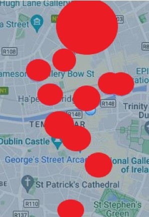
He shared maps which show Dublin, Cork and Limerick covered in large red circles, and which appear to show the areas around health centres that would be affected by such legislation.

However, Mullen’s tweet contains a number of contentious claims.

Is it the case that there have been no harassment near centres that provide abortion? Does the bill restrict movement or assembly? And are the maps accurate?

Let’s take a look.

What does the bill say?

The Health (Termination of Pregnancy Services) (Safe Access Zones) Bill 2023 would, if passed, forbid people from threatening, impeding access, or “communicating material” that is anti-abortion within 100 meters of the entrance to GP offices, obstetricians practices and hospitals which provide “acute in-patient services”.

Filming or photographing people “with intent to influence the decision of such a person” to terminate a pregnancy is also forbidden.

There are exceptions though: protests outside the Houses of Oireachtas (provided they don’t target a healthcare premises in the immediate area) are allowed, as are buildings used for religious worship.

Information given by healthcare providers themselves would also be permitted.

The proposed legislation outlines that, where there is a potential offence, Gardaí may first warn people that they could be in breach of the law.

Punishments would be reserved for those who continue to break the rules after they have been given a warning, with fines of up to €2,500 or six months’ imprisonment.

However, the legislation contains no references to “freedom of movement and assembly” as Mullen referenced in his tweet.

A member of Rónán Mullen’s staff responded to an email from The Journal asking how he believed the bill would limit an individual’s freedom of movement or assembly.

“The map was time consuming to make, as you will appreciate in doing this fact check, and does not allow for any future premises that may arise,” the response read in part.

“We must do our best on scarce resources.

“The Minister should have sought to provide such maps to accompany the 2nd Stage debate given the scale of restrictions on freedoms involved in section 2 of the Act” 

Previous protests

 The proposed bill would outlaw forms of behaviour that has happened in the past.

Since the referendum in 2018 on repealing the Eighth Amendment, which allowed for the legislation of abortion, anti-abortion campaigners have protested outside hospitals that they believed to be providing abortions, often holding signs that say abortion is equivalent to murder.

Other forms of protest included people distributing leaflets, or “entering surgeries to complain about the service” according to a Maynooth University Associate Professor’s survey of healthcare providers.

Protesters have told The Journal that they demonstrated near entrances to the hospital on days that they believed people would be attending to terminate a pregnancy.

Similar protests, often displaying banners with graphic imagery, had been held in 2018 before and after the referendum had taken place.

Mullen’s tweet containing the map of Dublin claimed that Minister for Health Stephen Donnelly was pushing through legislation for Safe Access Zones “despite there being no recorded incidents of harassment around centres that provide abortion”.

At the time of writing, Gardaí did not respond to inquiries about official complaints of such harassment. 

Are the maps accurate?

A quick look at the maps posted by Rónán Mullen, apparently showing the areas that would be affected by Safe Access Zones, shows giant red dots over certain locations in the city.

They include hospitals, such as the Rotunda in Dublin, as well as small dots over GP offices that can be found readily on Google Maps. Many of the circles, however, remain a mystery.

It is unclear what, if any, medical premises they refer to.

The maps are too small and (as we will discuss in more detail) the dots are not accurate enough to determine the exact address at the centre of many of them.

A member of Rónán Mullen’s staff told The Journal that they could not say what medical centres were being referred to in the maps due to privacy laws.

“GDPR rules do not allow us to share the names of premises but there are various public records available,” the staff member said.

The response received by Mullen’s office also offers other puzzling issues. It begins: “These are 100m zones measured from extremities of any building envisaged by the legislation where a designated health care provider may operate.”

However, the legislation does not create Safe Access Zones from the extremities of buildings, but from their entry and exits.

There was no response to follow-up email from The Journal to Rónán Mullen’s office asking where they had sourced information on healthcare providers, or why GDPR would apply to already public information about health centres.

As such, we have examined the maps more closely to see whether it’s possible to figure out whether they refer to healthcare providers.

Dublin

The map of Dublin is dominated by a giant circle at the top, which appears to represent the Rotunda Hospital on Parnell Square.

Even accounting for the maps measuring from the “extremities of any building” (as Mullen’s office said), rather than its entryways, the map still drastically overstates the size of the Rotunda’s potential safe access zone.

F0XRH1YWYAAj_BW Map posted by Rónán Mullen

For example, to the northwest of the Rotunda, (which has no entrances, as it is blocked off by the Garden of Remembrance), the radius of the circle clearly overlaps with the N1 road, despite that being more than 165 metres away from the Rotunda’s buildings.

Google Maps showing the distance from the extremities of the Rotunda Hospital. Google Maps showing the distance from the extremities of the Rotunda Hospital.

To the southwest, the radius of the circle covers Dominick Lane, while to the southeast the intersection between Tomas Lane and Cathal Brugha Street is obscured. Again, both these areas are substantially further than 100m from the Rotunda Hospital.

The 100m circles surrounding the Rotunda Hospital and the Jervis Medical Centre touch together on the Senator’s map, despite being centred on buildings that are more than 350 meters away from each other.

Google Maps Google Maps

There was also one red circle on the Dublin map we could not identify a potential referent for.

Cork

Similar issues arise on the map of Cork, though Mercy University Hospital dominates the top of map this time.

The borders of the theoretical Safe Access Zone emanating from this is most exaggerated in the southward direction where it crosses the River Lee to where the Lavitt Gallery is located, at least 300 meters away.

Google Maps Google Maps

Another giant circle closer to the centre of the map appears to be a combination of City General Hospital and other GP offices in the area, merged into one inaccurate circle, which clearly crosses over the Lee onto the South Mall.

Again, there is no interpretation of this that makes sense; City General Hospital is more than 450 metres from this area, and while there are GPs closer, including one office about 100m from the river, none would create a radius like that seen in the Senator’s map.

The Journal was again unable to identify any referents for some of the circles. 

Limerick

Issues with the radius of the circles again appear on the Limerick map, but this map had, by far, the most amount of circles that do not appear to be associated with a relevant healthcare provider.

An example of the exaggerated radius can be seen around the bottommost circle, which appears to depict the RoyalMed Health Centre.

However, while this circle appears to be centred in roughly the right place, it extends west of Prospect Hill, going well past the junction with Wolfe Tone Street, despite that being 100 meters from the “extremities of any building” of the RoyalMed Health Centre.

Google Maps Google Maps

However, a more pressing issue is that many of the circles are centred on areas that don’t appear to be relevant at all.

For example, the most southeastern circle on the map is centred on St Anne’s Day Hospital, a mental health outpatients service. The St Anne’s confirmed to The Journal that they do not provide GP, obstetrician or “acute in-patient” services.

Radius of circles

It should also be noted that many of the circles represented in all three maps overlapped with large blocks of buildings – in other words, places where protesters would not have access to.

The bill itself only forbids campaigning against abortion in public places, or gardens, lands, car parks, entrances and windows facing onto public spaces. 

In many cases, a more accurate extent of the bill’s scope would be depicted using a straight lines along the roads that run by the healthcare centre’s entrance, rather than the entire area of a circle. 

Moreover, many of the red circles overlap with large churches or other places of worship, the buildings of which are specifically excluded from the rules given in the legislation.

The office of Rónán Mullen did not reply to The Journal’s inquiry on why this was.

The maps showing potential Safe Access Zones tweeted out by Senator Rónán Mullen therefore exaggerate the size of these zones.

It is simply misleading to suggest that the entire locations covered in red in maps on social media by Mullen would be affected.

The Journal’s FactCheck is a signatory to the International Fact-Checking Network’s Code of Principles. You can read it here. For information on how FactCheck works, what the verdicts mean, and how you can take part, check out our Reader’s Guide here. You can read about the team of editors and reporters who work on the factchecks here.