Sign in. It’s quick, free and it’s up to you.
An account is an optional way to support the work we do. Find out more.
Sign in. It’s quick, free and it’s up to you.
An account is an optional way to support the work we do. Find out more.
A NATIONWIDE STATUS Yellow wind warning remains in place as Storm Dudley passes over Ireland, while a new snow warning has been issued for Friday.
A Status Orange wind warning has also been issued for seven counties for Friday, when Storm Eunice is set to hit the country.
Today’s weather warning will be in effect until 11.30pm. Met Éireann initially issued the warning until midday tomorrow, but downgraded it this morning.
The forecaster is currently reporting gusts of up to 70 to 95km/h in places, stronger on exposed coasts and on high ground, while westerly winds are reaching mean speeds of 45 to 60km/h.
ESB is working to restore power to hundreds of homes across the country affected by the strong winds.
Latest information from the PowerCheck service shows a number of outages in areas across the country.
The ESB said crews are currently working to restore power in affected areas as quickly as possible.
Here are the latest wind observations from across Ireland at 8pm🍃
— Met Éireann (@MetEireann) February 16, 2022
⚠️Wind warning in place until this evening⬇️https://t.co/ZbI0RkUYIb#StormDudley pic.twitter.com/gKHtqXaq7X
Met Éireann said earlier that a combination of high tide and strong winds would lead to flooding on exposed coasts.
Heavy rain is set to turn to showers with winds due to ease at midnight ahead of the arrival of Storm Eunice, which is expected to hit Ireland tomorrow.
A Status Amber wind warning is in place for Antrim and Derry until midnight.
A Status Yellow wind warning is currently in effect for Antrim, Armagh, Down, Fermanagh, Tyrone and Derry until 6am tomorrow.
Met Éireann this morning issued a Status Yellow wind and rain and snow warning for the entire country, valid from 1am to 3pm on Friday.
A Status Orange wind warning has also been issued for Clare, Cork, Kerry, Limerick, Waterford, Galway and Wexford, valid from 5am to 11am on Friday.
The forecaster said the storm will bring “severe and potentially damaging winds”, gusting up to 130km/h, higher in exposed areas.
It added that some disruption is expected along with “a possibility of coastal and spot flooding” and that its warnings will be updated on Thursday morning.
Met Éireann meteorologist Matthew Martin said that Storm Eunice is set to bring some “challenging” weather conditions on Friday.
“We’re keeping a very close eye on the forecast for Friday as Storm Eunice is expected to bring some challenging weather conditions, especially on Friday morning as strong winds, heavy rain and snow moves across the country,” said Martin.
At the moment it looks like northern and western areas are most likely to see the heaviest snow falls, with southern areas expected to see the strongest winds, however we’re still a few days ahead and the details of when and where are likely to change. With this in mind, we’re urging people to keep a very close eye on the forecast and warnings for their area as these may change in the coming days.
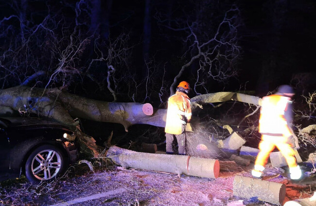
Met Éireann said Storm Eunice is also likely to bring a risk of fallen trees from strong winds and hazardous driving conditions, and possibly disruption to transport from heavy rain and snow.
While Status Orange warnings will be in place for seven counties, the Department of Education says that there are no plans to close schools in counties impacted by the warnings.
#StormDudley
— Dublin Fire Brigade (@DubFireBrigade) February 16, 2022
Firefighters from Donnybrook fire station and public lighting crews from @DubCityCouncil were called to #Ballsbridge after high winds damaged a lamp post. Working with @ESBNetworks the scene was made safe. pic.twitter.com/srJxU0eRD2
“There is no indication of any school closures required as a result of Storm Eunice at this stage,” a spokesperson for the Department said.
Commenting on the possibility of coastal impacts, Met Éireann’s hydrometeorologist Jennifer Canavan said: “We’re in a period of high tides at the moment and this in combination with strong winds and stormy conditions means there is a high risk of large coastal waves and coastal flooding on Friday, especially along southern and eastern coasts.
“As such we’re urging people to take extreme care near coastal areas and paths,” she said.
The UK Met Office has also issued a Yellow wind and snow warning for Northern Ireland, valid from 3am to 6pm on Friday.
The National Directorate for Fire and Emergency Management (NDFEM) Crisis Management Team held a second virtual meeting today with Met Éireann, the OPW, local authorities, the principal response agencies, key departments and responding national organisations in preparation for Storm Dudley today and Storm Eunice on Friday.
The NDFEM Crisis Management Team “will continue to liaise with Met Éireann to monitor the evolving weather situation and intends to conduct further meetings of the group over the coming days”, a statement noted.
A further meeting of the group is scheduled for 12.00pm tomorrow.
The group are urging all members of the public to heed local authority advice and monitor Met Éireann forecasts for updates.
General public safety advice issued by the group is as follows:
The RNLI has urged the public to exercise extreme caution if visiting the shoreline, especially along exposed cliffs, seafronts and piers.
Lisa Hollingum, RNLI Water Safety Delivery Support, said: “The expected storms could make our seas treacherous, increasing the risk for those visiting the coast around Ireland.
“In a normal year around, 115 people lose their lives at the coast and we know that more than half of those never intended to be in the water. So, whether you are walking, running or cycling at the coast, please be extra responsible and avoid taking unnecessary risk or entering the water.
“In particular, we ask people to stay well back from stormy, wintery seas and cliff edges, check tide times before you go, take a phone with you, and call 999 or 112 and ask for the Coast Guard if you or someone else is in trouble.”
Met Éireann echoed the RNLI’s calls for people to be careful in coastal areas, with potential risks of coastal flooding and large coastal waves in some areas, particularly in the southern and eastern coasts.
The RNLI’s main advice is as follows:
With reporting by Jane Moore and Tadgh McNally

To embed this post, copy the code below on your site


have your say