Sign in. It’s quick, free and it’s up to you.
An account is an optional way to support the work we do. Find out more.
Sign in. It’s quick, free and it’s up to you.
An account is an optional way to support the work we do. Find out more.
LAST UPDATE | 11 Mar 2019
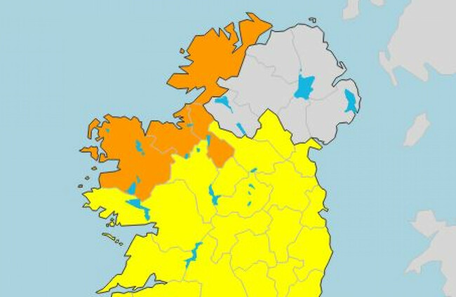
A STATUS ORANGE wind warning has been issued for four counties in the north and west of the country as Storm Gareth approaches.
The warning covers Donegal, Leitrim, Mayo and Sligo. It comes into effect from tomorrow at noon, and will remain until Wednesday morning at 9am.
“As Storm Gareth approaches, westerly winds will reach mean speeds of 65 to 75km/h with damaging gusts reaching 110 to 130km/h. There is also the risk of coastal flooding due to high seas,” Met Éireann said.
A Status Yellow rainfall warning will be in place for Connacht, Donegal, Clare, Cork, Kerry and Limerick from 6pm today until 6am tomorrow.
According to that warning:
Heavy rain followed by squally showers will lead to the risk of rainfall accumulations of around 25mm.
A Status Yellow wind warning is in place nationwide from noon on Tuesday until noon on Wednesday. According to Met Éireann:
Westerly winds will reach mean speeds of 50 to 65km/h and gusts of 90 to 110km. There is a risk of coastal flooding due to high seas along Atlantic coasts.
Weather for today
According to Met Éireann, this morning will be mostly dry with rain spreading from the west through the later afternoon and evening. There will be afternoon highs of 6 to 10 degrees.
Rain is set to turn heavy tonight, with a risk of spot flooding and strong winds. The rain will turn to more isolated showers later in the night. Mild at first, but temperatures dropping to between 1 and 4 degrees around dawn.
Tomorrow will see more isolated showers, with rain turning heavier in the north and northwest.
As they day progresses it will become increasingly windy, with southwesterly winds veering westerly and increasing strong to gale force and gusty by the late afternoon.
- with reporting from Gráinne Ní Aodha

To embed this post, copy the code below on your site


have your say