Sign in. It’s quick, free and it’s up to you.
An account is an optional way to support the work we do. Find out more.
Sign in. It’s quick, free and it’s up to you.
An account is an optional way to support the work we do. Find out more.
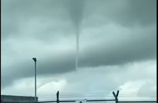
A NUMBER OF social media users have posted videos and pictures online of a funnel cloud forming over Dublin Airport.
The videos show a narrow, spiraling cloud formation that looks to the untrained eye like a small tornado. Unlike tornados though, funnel clouds do not make contact with the ground but remain suspended in the air.
Irish tornados are usually weak and do not pose a substantial risk to people and property.
The Carlow Weather Twitter account has posted a number of videos of the curious weather phenomenon.
— Jim Egan. (@jim_eganj) June 20, 2023
A Twitter user called Jim Egan also shared footage that showed the cloud near Dublin Airport this afternoon.
A DAA spokesperson confirmed to The Journal that all flights at Dublin Airport are operating normally all day.
Met Éireann has since shared an explanation for the weather phenomenon on Twitter after being sent footage.
The forecaster explained that funnel clouds extend from the cloudbase and are formed due to a rotating column of air.
It said the phenomenon is usually associated with “cumulonimbus clouds” – the type that produces hail, thunder and lightning. There was heavy rain and thunder and lightning in north Dublin this afternoon.
Met Éireann added that cumulonimbus clouds are classed as a tornado if they reach the Earth’s surface.
Funnel clouds 👇🌪️ extend from the cloudbase and are formed due to a rotating column of air.
— Met Éireann (@MetEireann) June 20, 2023
They're usually associated with cumulonimbus/⛈️clouds, and are classed as a 🌪️if they reach the surface.
There were some very heavy showers & ⛈️in that area and over Dublin this afternoon https://t.co/IrIY8zOHZO pic.twitter.com/TRpFsi3CD2
It comes as a Status Orange thunderstorm warning is in place for the entire country.
The thunderstorms come with the possibility of some hail and localised flooding, according to the forecaster.
The warning was upgraded this afternoon after a country-wide yellow warning was issued early this morning.
The six Northern Ireland counties are currently covered by a Status Yellow warning, which is valid until 8pm tonight.
The Met Éireann warning is in place until 6pm and warns of flash flooding, very difficult traveling conditions with reduced visibility and power outages.
With reporting by Jane Moore

To embed this post, copy the code below on your site


have your say