Advertisement

We need your help now

Support from readers like you keeps The Journal open.

You are visiting us because we have something you value. Independent, unbiased news that tells the truth. Advertising revenue goes some way to support our mission, but this year it has not been enough.

If you've seen value in our reporting, please contribute what you can, so we can continue to produce accurate and meaningful journalism. For everyone who needs it.
WFDIreland.ie
flood solutions

'Dredging the Shannon would ease flooding in some areas, and make it worse in others'

What can be done to solve the flood problems in the Shannon basin?

THIS WEEK, WE saw major floods affect areas that stretched from Carrick-on-Shannon to Athlone, to south Clare. 

In Shannon Harbour, a small village in Co Offaly, three locals were working together to try to source a pump to relieve the threat they were under. Each year, usually during the winter, the threat of a flood looms over them.

The issue of floods is one that is expected to worsen as time goes on. Before, it was expected that we would get major floods once every decade, or every 100 years even; now that’s changed to once every four years or so, going by the last 15 years. 

We don’t have enough data to say for sure that this is climate change related, but it is part of a Europe-wide pattern; rivers are drying up in some areas, and getting stronger, with more forceful currents in others.

So the issue of flooding along the Shannon catchment area is likely to get worse, both through frequency from year-to-year, and the volume of water that is spilling over banks, gathering on people’s land and threatening their homes.

So what’s being done about it by Irish authorities, and is it enough?

The extent of the floods

Dr Mary Bourke, an assistant professor of geography at Trinity College Dublin, said that because we only have data going back to the 1960s about our rivers, “we can’t say definitively” that increasing flood levels are related to climate change, and it’s “unreasonable to try to predict” when and what kind of floods there will be in the future.

The data we do have from the 1960s shows that for each decade the floods increase by 5% (that’s measured in the cubic metre of water released per second).

She calls this “significant”, and notes that the change is not the same for all European rivers: “Some are drying up, and others are getting wetter.”

What is the government doing?

Part of the government’s strategy is a European Union-wide approach, which means taking a number of measures. 

This is being done through the Water Framework Directive (WFD), which is European legislation that promotes a new approach to water management through river basin planning. It covers inland surface waters, estuarine waters, coastal waters and groundwater.

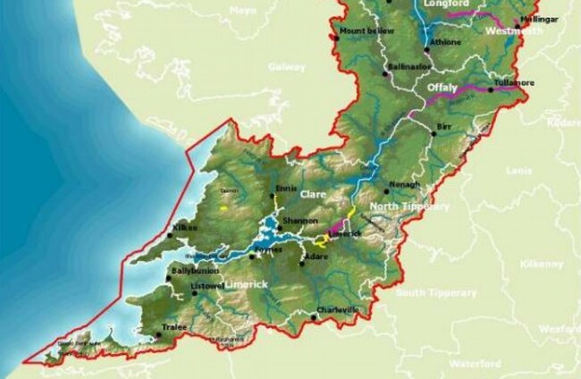
Phase one took place up until 2015, and we’re now in phase two (Catchment.ie illustrates the water status all over Ireland with a very helpful interactive map). 

Flooding Catchments.ie Catchments.ie

It involves analysing the current situation with floods in Ireland, looking at what is situated along the Shannon: is it a high-value industry, a farm with a disused shed, and puts a value on that. It then assesses how much it would cost to defend these properties.

In a statement to TheJournal.ie about the actions being taken to fight flooding in areas around the Shannon, the Office of Public Works (OPW) said cited the Catchment Flood Risk Assessment and Management (CFRAM) Programme, and its Flood Risk Management Plans (FRMPs).

“A Shannon study included 67 of the 300 areas in total studied with over 17,800km2 of river being surveyed and modelled and over 10,000 individual flood maps produced to highlight the flood risk along the Shannon catchment,” the statement said.

The FRMPs that include 34 new flood relief schemes to protect towns in the Shannon River Basin District, as part of the government’s €1 billion investment in flood relief over the next decade.

“These new schemes are in addition to 13 schemes already completed or under construction,” the OPW said. “Together, these will protect 95% of properties against their significant risk from flooding.”

Work is now complete or underway to protect 80% of at risk properties; details of these schemes are available on www.floodinfo.ie.

Dredging the Shannon

This has been suggested by a number of people affected by the flooding, as well as a number of local politicians.

“Dredging is used for navigation to help boats move up and down an area easier, and increase capacity of a channel to hold its flow,” Dr Bourke says. “If a certain area needs to move water much quicker, dredging can do that.”

But she adds that there can be negative hydrological and ecological effects to dredging.

There’s a misunderstanding about how rivers work: If you’re shooting out water at a high speed, that will have a knock-on effect down to the next village and others that live in that area. 
No one can do anything along the river without it affecting those further down: with a faster current, you’re eroding the banks downstream, and putting bridges under pressure. Will they be able to withstand a more powerful stream? Will people’s lives be at risk because of this?

Bourke wonders have measures been taken in some areas that are already negatively affecting others further downstream.

She adds that dredging can work to reduce smaller floods, but says that where it would not be effective is “to manage the floods in the Shannon”. 

The OPW said that in December last year, the government agreed to support an investment of €7 million to “advance a planned programme of maintenance works and the removal of constrictions or ‘pinch points’ on the bed of the River Shannon at the Callows Region between Athlone and Meelick Weir to halt the deterioration and to improve the conveyancing of the River Shannon”.

“This investment includes the costs for the full environmental assessments required to progress the works to the planning process to obtain consent to proceed.”

The OPW said that it also operates a ‘Minor Works Flood Mitigation Works and Coastal Protection Scheme’, where applications can be made by local authorities and are considered for projects that are estimated to cost not more than €750,000 each.

“Funding of up to 90% of the cost is available for approved projects. Applications are assessed by the OPW having regard to the specific economic, social and environmental criteria of the scheme. Full details of this scheme are available on www.opw.ie.

Farmers

One of the arguments for dredging is that there is a bed of silt, or clay, lying at the bottom of some rivers that has an impact on the water levels, and needs to be dredged.

An alternative is to stop this silt reaching the rivers in the first place. This could be done by encouraging pools of water to sit on farmers’ fields instead of it running down into rivers.

“How farmers are persuaded to do it varies: you can offer to build a pond, or a bridge using the new Common Agricultural Payment from the EU,” Bourke suggests, adding it doesn’t have to be a flat payment.

She says that allowing the rain to leak down into wetlands and forests can reduce the height of floods, and that Scotland and Yorkshire are “amazing examples of this”. But this would also only work for small catchment areas. 

“We have to sacrifice flood areas and accept they will be wet, and defend other areas.”

The 1% flood

“I think it’s absolutely tragic, shocking,” Dr Bourke says when asked to assess the flood damage done to people’s homes.

“A lot of the building is not very well planned or thought out – these people were not fully informed that they could have been building on a flood plain. They may have been told it was a ’100-year-flood area’ and interpreted it as ‘once in 100 years’.”

There’s a massive misunderstanding by certain news agencies about the ‘once in 100 years’ flood. It’s a 1% chance every year: what it actually means is that in any year, we have a 1% chance of something happening.

Bourke says that more flooding is not the only problem – it’s drought as well. A research paper highlighted that in the 1800s in Ireland, there was a drought that lasted a decade. So not only should we prepare for floods, efforts should be made to store rainwater, too.

“They can harvest and store the rainfall using sustainable urban drainage systems (SUDS). We can begin to use permeable materials, like highly-porous cement, for footpaths, so the water will sit there and slowly seep through.”

We should not talk about floods only when it’s flooding.

Do we need one authority for the Shannon?

Sinn Féin leader Mary Lou McDonald and a number of councillors and experts have suggested that one authority for looking after the River Shannon would help tackle flooding challenges. 

Along with the OPW, the ESB manages dams such as the Parteen Weir, and Waterways Ireland also have responsibility for rivers.

The Shannon Flood Risk State Agency Coordination Working Group almost already does this: it was established in 2016 to support existing plans to address flooding, and to enhance the cooperation of all State agencies involved with the River Shannon.

The Group was established, at that time, following severe flooding arising from exceptional weather conditions in December 2015/ January 2016. It has a useful series of FAQs, available at this link.

The OPW said that “on its establishment, a priority for the group was to develop a work programme that demonstrated the extensive range of activities and coordination by all State agencies already underway to jointly and proactively address flood risk along the Shannon”. 

Among the decisions the group has taken, are:

  • “Targeted maintenance” at a number of locations on the River Shannon
  • A study to examine the removal of constrictions resulting in lower summer water levels through the Shannon Callows, to help address the summer flooding in this area while maintaining the appropriate navigation requirements
  • A study to examine the cause, degree and rate of restriction downstream in the Lower Shannon
  • Pilot lowering of lake levels in Lough Allen to help alleviate any significant flooding event that may occur. The group is also completing an environmental assessment of this pilot to help inform any decision to target a reduction in lake levels
  • An assessment of the potential for strategic maintenance on the River Shannon.

Taking matters into local hands

Bourke says that local communities shouldn’t completely rely on authorities, either.

“We should also know that we have the power as communities to set up river trusts, which allow people to take control over the problems they see for their rivers. They’re cleaning-up systems,” she says, citing the Inishowen Rivers Trust as an example.

The charitable group aims to conserve, protect, rehabilitate and improve the rivers and natural water bodies of the Inishowen Municipal District. In August 2017 Inishowen was hit by severe flooding, which left many devastated areas around the peninsula. 

In an effort to understand the flood and look at ways forward, the Inishowen Rivers Trust organised an event in February 2018 entitled ‘Slow the Flow’ which brought flood experts to Inishowen. Bourke has carried out research on retaining natural water in the area.

“People have been completely traumatised and tired from the lack of action. The Inishowen River Trust keeps pushing for the OPW to fix this, that and the other,” she says, but they have also taken initiatives upon themselves.

The IRT board has about 10 people on it, and volunteers help when it floods. The group is organic, which is not unique but it’s pretty special.

Your Voice
Readers Comments
46
This is YOUR comments community. Stay civil, stay constructive, stay on topic. Please familiarise yourself with our comments policy here before taking part.
Leave a Comment
    Submit a report
    Please help us understand how this comment violates our community guidelines.
    Thank you for the feedback
    Your feedback has been sent to our team for review.

    Leave a commentcancel