Sign in. It’s quick, free and it’s up to you.
An account is an optional way to support the work we do. Find out more.
Sign in. It’s quick, free and it’s up to you.
An account is an optional way to support the work we do. Find out more.
LAST UPDATE | 19 Oct 2023
COMMUNITIES IN THE south of the country are reeling from the effects of major flooding due to heavy rainfall yesterday.
A Status Orange Rain warning was in place for Cork and Kerry early yesterday amid Storm Babet, followed by a Status Yellow warning across the country. Wexford, Wicklow and Waterford were also subject to an Orange warning for several hours in the afternoon.
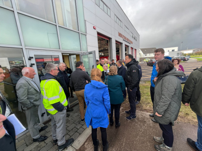
Several politicians, including Taoiseach Leo Varadkar, have travelled to Cork today to the epicentre of the damage.
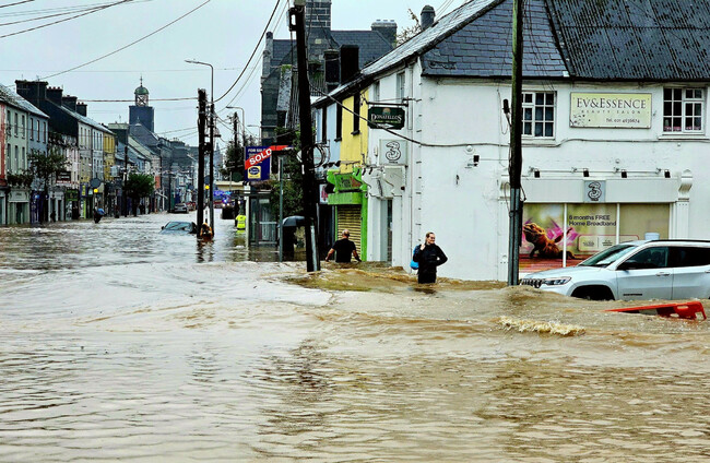
The storm brought knee-high flooding to parts of Cork, particularly the town of Midleton, where members of the Defence Forces were deployed as buildings flooded and roads were cut off.
Cork County Council appealed for road users to take care when travelling today and to be conscious of pedestrians and cyclists while multiple roads were still closed and impassable due to flooding.
Lisa O’Connell saw the front window of her salon smashed due to the conditions.
She told The Journal that the salon was suddenly hit by flood, causing staff and customers to wade “waist-deep” in water to get to safety.
“We’re a very busy salon full of clints. But just like in the blink of an eye, the water just started coming up and pouring into the salon and it was like we were nearly outside was like knee-deep within about kind of five minutes.”
Damian O’Brien, who runs two clothing stores in the town, said it was devastating.
“We couldn’t get ahead of things here. All businesses are saying the same thing. It’s nature and all that but sandbags weren’t there when we needed them, until it was almost too late.”
Cork County Council, which said more than a month’s worth of rain fell in the space of 24 hours, established a response co-ordination centre at Midleton Fire Station and a rest facility in Midleton Community Centre for residents who had been evacuated.
The council’s Severe Weather Assessment Team has convened to assess the impact of the flooding. Efforts to address immediate concerns today are focused on restoring essential services, securing affected areas, and supporting impacted residents and businesses, according to the council.
Between 5pm yesterday and 9am this morning, the council responded to 57 calls for assistance.
The council is offering free disposal of flood-damaged goods at all of its Civic Amenity Sites until 26 October. Raffeen Civic Amenity Site is closed due to flooding but the site in Youghal has reopened to the public. Skips are to be made available in the worst affected areas.
Members of the public have been asked to continue to avoid Main Street in Midleton to allow for clean-up operations; to avoid driving through floodwaters; and to be especially conscious of vulnerable road users like cyclists and pedestrians.
Trains between Cork Kent in the city centre and stations at Cobh and Midleton are still suspended this morning. Bus transfers are operating on the Cork commuter network but are not possible to Glounthaune or Midleton due to flooding, according to Iarnród Éireann.
Local TD James O’Connor has said it is “devastating” to see the extent of the damage caused in Midleton and has questioned why a Status Red weather warning was not issued.
“Widespread damage across East Cork will require major support from the government,” O’Connor wrote on social media.
Midleton has always been the beating heart of East Cork. It’s devastating to see the extent of the damage here. Met Éireann must urgently explain why no red level weather warning was issued. Widespread damage across East Cork will require major support from the government. pic.twitter.com/5gNLdmzBYD
— James O'Connor TD (@JamesOConnorTD) October 18, 2023
Storm Babet is the second named storm this season and is also affecting the UK. In Scotland, the Met Office issued a rare red weather warning for parts of the country where it believed there was “danger to life from fast-flowing or deep floodwater”.
Meanwhile, in Waterford, a council official stated that several roads were still flooded and expected to remain that way for the duration of today.
Waterford City and County Council’s Director of Services, Fergus Galvin, told RTÉ Radio One’s Morning Ireland this morning that he and his colleagues cannot recall any worse flooding event.
“It’s unprecedented in recent times. None of them would have any recollection of a scale of flooding of this order in the last 30 or 40 years,” Galvin said.
“Some of the roads are still underwater this morning. We would expect that will remain the case for much of the rest of the day,” he said.
“We would be aware from some preliminary surveys yesterday that we will have structural damage to a number of places and local roads in the west of the county but we will have to wait until the floodwaters recede to get a full picture of those.”
Storms that can cause major impacts like flooding are expected to become more frequent and more intense as climate change disrupts weather patterns.
The Climate Action Plan 2023 states that the “most immediate risks to Ireland from climate change are predominantly those associated with changes in extremes, such as floods, droughts, and storms”.
Extreme rainfall and flooding can cause “disruption of transport services, unsafe driving conditions and gradual deterioration of infrastructure”, it details, while “projected increases in the frequency of extreme precipitation events may result in more water-borne disease (eg E.coli) from contamination of drinking water because of overland flows of pollutants”.
Met Éireann’s Chief Hydrometeorologist Eoin Sherlock has explained that the intensity of yesterday’s flooding was due to a combination of factors.
Speaking to Morning Ireland, Sherlock said: “We had an awful lot of rain falling in a relatively short period of time. Coupled with that, the ground was saturated beforehand because we had some heavy rain in the in the preceding days. So unfortunately, when that rain fell in a short period of time, it had nowhere to go except into the rivers and down to lower ground.
“We had high tide during the morning, so that has the effect of limiting the outflow of the river into the sea – so basically, there’s nowhere for that excess water to go except up and up and unfortunately it spills over the banks at that point,” he outlined.
On how Met Éireann decides what type of warning to issue ahead of an extreme weather event, he said that the forecaster uses Irish and European weather models to inform its predictions.
“The model guidance was suggesting that it would be Orange. When we look at the figures that fell on the ground in that particular period of time, I think we had one or two stations where it creeped into Red territory,” he said.
“Other parts of Cork were in Orange level territory in terms of amount of rainfall and then parts of Cork were below or even just creeping into Yellow. The way we do it is we look at, is it going to be a widespread event? Will it affect all of Co Cork?
“The guidance that we got and, when we were watching this unfold, what the observations were tallying with, was that I think maybe in two stations, we crept over 80, and that would be the upper threshold for an orange warning,” he said.
Sherlock said that the thresholds for weather warnings and how Met Éireann communicates about them will change as Ireland’s long-term climate also changes.
“The climate has changed, there’s no doubt about that, that’s unequivocal. We’ve gotten warmer; we’ve seen temperatures increase by point seven degrees since the last round of climate averages in the last 10 years,” Sherlock said.
“We can expect more extreme rainfall because the temperature has increased. So, what we’re doing now is we’re looking at the thresholds that we have for the warnings and are going to change them in reflection of what’s happening in the climate,” he said.
“Another thing that we’re trying to do is to look at not only what the weather will be but what the weather will do. If you’ve been looking at our warnings over the last couple of days, we have been warning about flooding and we’ve been warning about difficult driving conditions.
“Maybe people don’t understand what 80 kilometre per hour winds are, but if we if we can inform people that there’s going to be flooding, they can take the necessary steps.
“As a quick recap: Orange is quite dangerous. There’s only one or two millimeters between an Orange rainfall warning and a Red.”
The floods were also raised during Leaders’ Questions today, where Tánaiste Micheál Martin said the rainfall was “very, very severe”. He applauded the community workers, the civil defence and the defence forces for responding so quickly.
Since he was young, Martin said he could remember flooding occurring in Cork. He said there was a need for an “honest debate” on the objections being submitted against flood relief plans around the country.
While he said he had not objections to submissions being made, he said when it results in years of delays, he does have a problem. People Before Profit Mick Barry raised concerns about the flood relief programmes in the county, for which Martin replied:
“You may recall your own comments in relation to the Cork City flood relief scheme where you described your OPW’s proposals as crude and not taking into account the people’s relationship with the River Lee.”
He said he wasn’t pointing it out to attack anyone, but said the realities needed to be highlighted that a debate on the issue is needed.
Enterprise Minister Simon Coveney also raised the issue during a visit to Midleton this evening, when he pointed to the success of flood relief infrastructure in other places.
“In Cork city centre, there’s been a lot of resistance to physical flood infrastructure to try and protect businesses and houses in the city centre,” he said.
“And I really think we need to reflect on that and try and protect businesses, families and homes.”
He added that many businesses hit by floods would not survive such levels of continuous flooding in the future, and that there was a need to look at what could be done to ensure that protection from flooding was stronger.
- With reporting in Midleton by Niall O’Connor

To embed this post, copy the code below on your site


have your say