Sign in. It’s quick, free and it’s up to you.
An account is an optional way to support the work we do. Find out more.
Sign in. It’s quick, free and it’s up to you.
An account is an optional way to support the work we do. Find out more.
LAST UPDATE | 30 Oct 2020
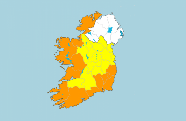
GARDAÍ ARE ADVISING people to avoid all unnecessary travel to the 12 counties where a Status Orange wind warning has been issued for tomorrow morning.
Met Éireann issued the orange wind warning for several coastal counties, after earlier issuing a Status Yellow warning for the whole country.
The warning will be valid at two different times, affecting different counties as Storm Aiden passes over the country.
The first warning is valid from 5am until 10am on Saturday morning, and applies to Kerry, Cork, Waterford, Wexford, Kilkenny, Carlow and Wicklow.
The second warning is valid from 8am until 4pm tomorrow in Donegal, Sligo, Mayo, Galway, and Clare.
In both cases, mean wind speeds of between 65 to 80km/h are expected, with “severe and damaging gusts” of up to 130km/h.
A Status Yellow wind warning is also in effect for the rest of the country between 1am and 3pm tomorrow.
Strong to gale force southerly winds are expected in those counties, with severe gusts also possible.
Met Éireann previously warned that spells of heavy rain could lead to surface and river flooding over the weekend. Some coastal flooding is also possible due to the combination of low pressure, high tides and onshore winds.
The Road Safety Authority (RSA) asked road users to exercise caution while using the roads over the weekend, and to be wary of hazardous road conditions.
Road users in areas affected by the warnings for strong winds are advised to check local traffic and weather conditions before setting out on a journey.
Likewise, An Garda Síochana has urged people to take care and exercise caution this weekend, in particular road users.
Gardaí are asking people to avoid all unnecessary travel, reminding motorists the expected winds will make driving conditions hazardous, especially for more vulnerable road users such as cyclists, pedestrians, motorcyclists and high sided vehicles.
“Road users should pay particular attention to the risk posed by fallen trees, flying debris and flooded roads,” a garda spokesperson said, adding that people are advised to remove or secure patio furniture, rubbish bins and any loose items from around buildings.
In Cork, which has been badly impacted by previous storms, the storm surge is predicted to add between 0.3m and 0.6m in height to tides and swells, with an increased risk of flooding in the county.
Current modelling by Met Éireann suggests that Saturday morning’s high tide poses the worst flooding risks, with high tide expected at 4.30am in Bantry and 5.05am in Ballycotton.
Cork County Council has advised road users to be aware of the danger posed by high winds, and warned motorists that driving conditions may be hazardous with surface flooding.
Today is forecast to be cloudy and damp at first, with scattered outbreaks of rain and drizzle. However, there will be bright spells and just a few well-scattered showers in the afternoon and evening.
It’ll be a dry and mostly clear start to tonight. However, Met Éireann said it will become wet and very windy later as rain sweeps northwards over the country, accompanied by strong to gale force south or southeast winds.
Some severe and potentially damaging gusts are forecast towards dawn.
Tomorrow morning is due to be wet and very windy, with spells of rain. Again, there will be severe and potentially damaging gusts for a time.
The windy conditions are expected to continue into the afternoon with a dry period and squally showers.
Conditions will become mostly dry by evening, with winds easing off. However, a further spell of wet and windy weather will spread from the Atlantic on Saturday night.
Rain is due to sweep into Munster early on and extend nationwide, along with strong to gale force southerly winds.
Looking ahead to Sunday, rain is expected to clear north-eastwards in the morning, with conditions becoming predominantly dry for a time.
However, another pulse of heavy rain will expect across the country during Sunday afternoon and evening.
Met Éireann has warned that strong southwest winds, potentially increasing to gale force, will occur. This rain is forecast to persist overnight with a risk of some localised flooding.
With reporting from Hayley Halpin.

To embed this post, copy the code below on your site


have your say