Sign in. It’s quick, free and it’s up to you.
An account is an optional way to support the work we do. Find out more.
Sign in. It’s quick, free and it’s up to you.
An account is an optional way to support the work we do. Find out more.
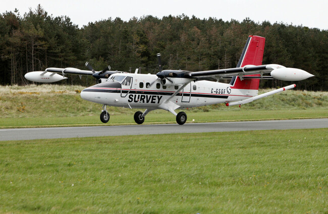
A LOW-FLYING AIRPLANE aims to have the entirety of Ireland mapped by the end of this year.
The Tellus survey, undertaken by the Geological Survey Ireland, is in its final stages of its project to map the entire country, finishing in counties Kerry and Clare this spring.
This geophysical survey began 14 years ago, and is a national mapping programme to collect geochemical and geophysical data on rocks, soil, and water across Ireland.
The survey plane will be flying at the height of 60 metres over rural areas, and 240 metres over urban areas over the coming months. The plane will fly in a grid pattern with scientific equipment to capture the data.
Last year, the low-flying plane surveyed counties Cork, parts of Limerick and sections of county Kerry.
Minister Darragh O’Brien said that the plane will have “flown all the far corners of the country.”
He added that the free data will be beneficial to companies, state agencies and researchers, as the survey will have data about the Earth’s subsurface, radon gas, environmental pollution, agricultural productivity, and the extent of peatlands.
The Tellus survey aims to have 100% of Ireland mapped by the end of 2025.
Data collected throughout the Tellus project is published and made freely available on the Geological Survey Ireland website.
The survey uses two aircrafts, which are white, twin propeller planes. They are easily identified by their red tail and black stripe as well as the word ‘SURVEY’ and registration numbers C-GSGF & C-GSGP written across both sides of the plane.
Due to the low-flying nature of the survey aircraft, Tellus have encouraged anyone concerned about sensitive livestock to contact the Tellus Freephone Information Line on 1800 45 55 65.
Geological Survey Ireland is a division of the Department of the Environment, Climate and Communications.
To embed this post, copy the code below on your site














have your say