Sign in. It’s quick, free and it’s up to you.
An account is an optional way to support the work we do. Find out more.
Sign in. It’s quick, free and it’s up to you.
An account is an optional way to support the work we do. Find out more.
WINTER IS FAST approaching but there is still the occasional fine day here and there to get out to
experience one of Ireland’s many fantastic heritage sites.
Here are three more suggestions in counties Limerick, Galway and Kerry. If you have a suggestion for a great site to visit please do leave a comment below.
Lough Gur, Co Limerick
Lough Gur in County Limerick is one of the most important and remarkable archaeological landscapes in Ireland. This small, horseshoe-shaped lake has been surrounded by human settlements and activity going back over 5,000 years ago during the Neolithic period.
This was a time of Ireland’s first farmers, people who began the back-breaking labour of clearing the vast forests that covered Ireland. The climate was a little warmer and drier than it is now and ideal for cereal cultivation.
Lough Gur is possibly most famous for its Neolithic settlement. Several houses, forming a small village, have been excavated on the south-facing slopes of the Knockadoon peninsula, which extends out into the lake. Both rectangular and circular houses were discovered.
People built these houses over 5,000 years ago by driving double rows of wooden posts into the ground. These posts supported a hipped roof and screens made from woven hazel rods known as wattle. The screens were covered in daub, a mix of dung, clay and straw which when dried, would have been an effective breathable, but water and draft-proof, wall. The houses may have been insulated with a layer of earth sods, reeds or straw.
An example of one of the rectangular buildings and a circular building have been reconstructed and now serve as Lough Gur’s Heritage Centre.
The Centre itself is very well laid out, with great information on the archaeology, history and folklore of Lough Gur. It has a number of superb reproductions of the incredible artefacts discovered in the area, and has informative interactive panels and exhibits making it fun for all ages. The visitor centre is an essential introduction to the complexity of archaeology in the region.
From the Centre, you can follow a looped walk to visit some of the archaeological sites in the area. Your first stop is ‘The Spectacles’ where you can see the foundations of a number of buildings and field systems dating to the early medieval period. As you follow the path beyond the Spectacles, you climb ever higher and get spectacular views over Lough Gur. From here you can see the landscape that has drawn people to the shores of this small lake for thousands of years.
When you have finished your visit to Lough Gur itself, a short drive up the road will bring you to the cashels of Carraig Áille (pictured above). These well-preserved early medieval stone ringforts have quite spectacular views, and are well worth the short climb up a hill.
Another short drive from Carraig Áille and you can find a wonderful example of an Early Bronze Age wedge tomb, similar (though smaller) to that of Labbacallee in County Cork.
The Lough Gur wedge tomb (pictured above) was excavated in 1938, and artefacts such as prehistoric pottery, flint and human remains were discovered. Wedge tombs generally date to the very late Neolithic/ Early Bronze Age period. Over 500 wedge tombs have been recorded in Ireland so far, making them the most numerous of Ireland’s megalithic tomb types.
Our next stop again just minutes along the road was the church ‘Teampall Nua’. This church is thought to date to the seventeenth century (though some architectural features look more medieval to me). It replaced an older chapel used by the Earls of Desmond.
Our final stop was Grange Stone Circle located just on the west of the lake and very easily accessible from the Limerick–Killmallock Road (R512). This stone circle is just incredible: it is massive, measuring nearly 50m in diameter. It is a near-perfect ring of 113 contiguous stones (all the stones are touching).
The entrance is marked with the tallest stones that are mirrored on the opposite side of the circle, apparently forming an alignment with the midsummer moon.
As an archaeologist I found the visit to Lough Gur to be almost like a pilgrimage. It is such a beautiful part of the country, and our visit barely scratched the surface of the sheer wealth of archaeological and historical sites clustered around the lake. A visit to Lough Gur is an absolute must for anyone with an interest in archaeology and history! You can find more information on Lough Gur from their website.
Clonfert Cathedral, Co Galway
Clonfert Cathedral in Co Galway is probably best known for its amazing doorway, the finest example of Romanesque architecture in Ireland. The Romanesque style of architecture was influenced by classical Roman and Byzantine architecture, and generally dates to the early medieval period, some time between the 8th – 11th Centuries AD across the continent.
It appears a little later in Ireland, and seems to coincide with large scale reforms of the Irish church in the twelfth century. The Irish builders incorporated their own styles with Romanesque to create a hybrid of the two, which is known as Hiberno-Romanesque architecture.
The doorway at Clonfert is in six ‘orders’ and has inclined jambs. Above the doorway, a steep triangular pediment is covered with Romanesque decoration showing animal heads, foliage, zig-zags, chevrons, but most striking of all are the individually carved human heads.
However, the Romanesque doorway was a late addition onto a church that was already famous in Ireland. It is referred to in the annals before 1050 as one of the four largest churches in the country (Annals of the Four Masters, Annals of Inishfallen, Chronicon Scotorum).
Clonfert is associated with Saint Brendan, he is said to have founded a monastery here in the sixth century. Brendan is known as The Navigator, and is one of the most famous of Ireland’s monastic saints. A ninth century book The Voyage of Saint Brendan the Navigator records his legendary journey to ‘The Isle of the Blessed’, a journey that involves sea monsters, strange islands and their inhabitants and that some people even believe to suggest that Brendan was the first European to discover America!
There are no remains of Brendan’s monastic site visible at Clonfert, though a gravestone in the churchyard marks the spot where he is allegedly buried.
As you pass through the doorway into the cathedral you may notice that the innermost part of the doorway is a later medieval (around the fifteenth century) addition, carved of grey limestone in contrast to the sandstone of the flamboyant Romanesque door. Much of the fine carvings and archway in the interior are also of fifteenth century date, and see if you can find a charming carving of a mermaid dating to this period too. She is similar to that at nearby Clontuskert.
Clonfert is certainly worth a visit to see the spectacular Romanesque doorway and the wealth of later fifteenth century sculpture inside. The graveyard was damaged recently by a freak tornado, though the cathedral itself remained undamaged.
You’ll find the site around 15km south-east of Ballinasloe, when you get to Laurencetown it is signposted down a minor road to the east off the R355 (Ballinasloe – Portumna Road) at coordinates 53.240651, -8.058621. You can find more information about Clonfert from their website.
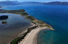
Loher Fort, Co Kerry
Loher Fort is an early medieval defensive farmstead that is beautifully positioned overlooking Ballinaskelligs Bay in County Kerry. It was probably the home of a local chieftain some time from the ninth – eleventh century.
The reconstructed circular drystone wall that surrounds the fort stands around two metres high with steps that lead to a wide rampart. In the interior of the enclosure you can find the foundations of two structures – one rectangular and one circular, presumably houses. When the site was excavated it was discovered that these stone buildings were later additions to the site, and replaced earlier wooden houses.
Within the circular structure archaeologists discovered the remains of a souterrain. These underground passageways typically date to the tenth or eleventh century, and there are a number of theories about what they were used for. Often people believe that they were used as refuges during raids, with the narrow passageway being difficult to assault and forcing any attackers to advance one at a time.
Alternatively they have been interpreted as an early form of a refrigerator or cellar, as they would maintain a constant cool temperature ideal for keeping the all important dairy products fresh. Unfortunately the souterrain at Loher Fort is now covered over and inaccessible, but the site itself is well worth a trip for its stunning views and atmosphere.
It is easy to find, follow the Ring of Kerry road N70 south of Waterville for about 5mins or so and you’ll see it signposted to the right. This is a narrow road and it goes on for around 10 mins, stick with it and you’ll see a decent carpark on your right and the fort below you. The co-ordinates are 51.78605509 -10.165658.
The Ring of Kerry is a beautiful place with a number of fantastic historical sites to visit, be sure to add Loher to your list of stops if you plan to visit the area!
If you’d like to keep up with daily images and information about Ireland’s fantastic heritage sites please consider following Neil’s company Abarta Audioguides on Facebook , Twitter, Instagram or Google+.
If you’d like to support Neil please consider downloading an audioguide from abartaheritage.ie: they are packed with great facts, information, stories and legends from Ireland’s iconic sites. They are designed to be fun and informative whether you are visiting the sites or from the comfort of your own home, so if you are looking to escape to the Court of Brian Boru the next time you are doing household chores, download one of our guides and let Abarta whisk you off to ancient Ireland!
All images © Neil Jackman/abartaheritage.ie

To embed this post, copy the code below on your site


have your say