Sign in. It’s quick, free and it’s up to you.
An account is an optional way to support the work we do. Find out more.
Sign in. It’s quick, free and it’s up to you.
An account is an optional way to support the work we do. Find out more.
A FAST-STRENGTHENING Hurricane Iota is sweeping over the western Caribbean and predicted to become a very dangerous Category 4 storm as it heads for the same part of Central America that was battered by a similarly powerful Hurricane Eta just over a week ago.
Evacuations were being conducted from low-lying areas in Nicaragua and Honduras near their shared border, which appeared to be Iota’s likely landfall.
Winds and rain were already being felt on the Nicaraguan coast last night.
Iota became a hurricane early yesterday and rapidly gained power, and was expected to pass over or near Colombia’s Providencia island during the night.
It became a dangerous Category 3 hurricane early today, and the US National Hurricane Centre warned it would probably reach Category 4 strength as it approached the Central America mainland later today.
The hurricane centre said Iota had maximum sustained winds of 125mph this morning.
It was centred about 190 miles east-southeast of Cabo Gracias a Dios on the Nicaragua-Honduras border and moving westward at 10mph.
It was already a record-breaking system, being the 30th named storm of this year’s extraordinarily busy Atlantic hurricane season.
Such activity has focused attention on climate change, which scientists say is causing wetter, stronger and more destructive storms.

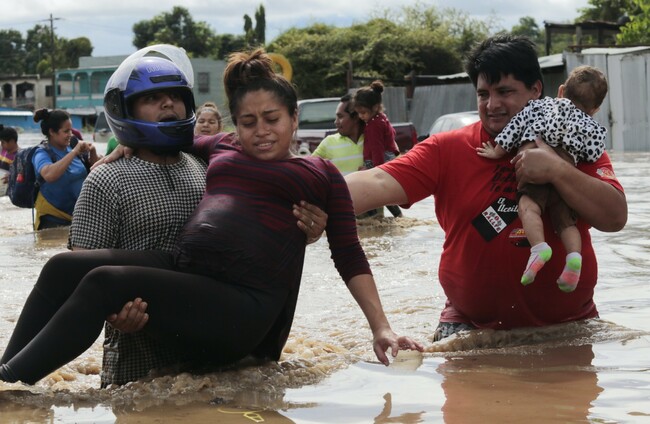
In Honduras, compulsory evacuations began before the weekend and by Sunday evening 63,500 people were reported to be in 379 shelters just in the northern region, while the whole country was on high alert.
Nicaraguan officials said that by late yesterday afternoon about 1,500 people, nearly half of them children, had been evacuated from low-lying areas in the country’s northeast, including all the inhabitants of Cayo Misquitos.
Authorities said 83,000 people in that region were in danger.
Wind and rain were beginning to be felt last night in Bilwi, a coastal Nicaraguan city where people crowded markets and hardware stores during the day in search of plastic sheeting, nails and other materials to reinforce their homes, just as they did when Hurricane Eta hit on 3 November.
Several residents of Bilwi expressed concern that their homes would not stand up to Iota, so soon after Eta.
Local television showed people being evacuated in wooden boats, carrying young children as well as dogs and chickens.
Authorities warned that the risk was high because Iota would probably come ashore over areas where Eta’s torrential rains left the soil saturated with water and more prone to new landslides and floods.
Eta already wreaked havoc. It hit Nicaragua as a Category 4 hurricane, killing at least 120 people as torrential rains caused flash floods and mudslides in parts of Central America and Mexico.
Then it meandered across Cuba, the Florida Keys and around the Gulf of Mexico before slogging ashore again near Cedar Key, Florida, and dashing across Florida and the Carolinas.
Iota was forecast to drop 8 to 16 inches of rain in northern Nicaragua, Honduras, Guatemala and southern Belize, with as much as 30 inches in isolated spots.
Costa Rica and Panama could also experience heavy rain and possible flooding, the hurricane centre said.
Eta was the 28th named storm of this year’s hurricane season, tying the 2005 record for named storms. Theta, the 29th, was far out in the eastern Atlantic Ocean, and became a remnant low on Sunday.
The official end of hurricane season is 30 November.

To embed this post, copy the code below on your site


have your say