Sign in. It’s quick, free and it’s up to you.
An account is an optional way to support the work we do. Find out more.
Sign in. It’s quick, free and it’s up to you.
An account is an optional way to support the work we do. Find out more.
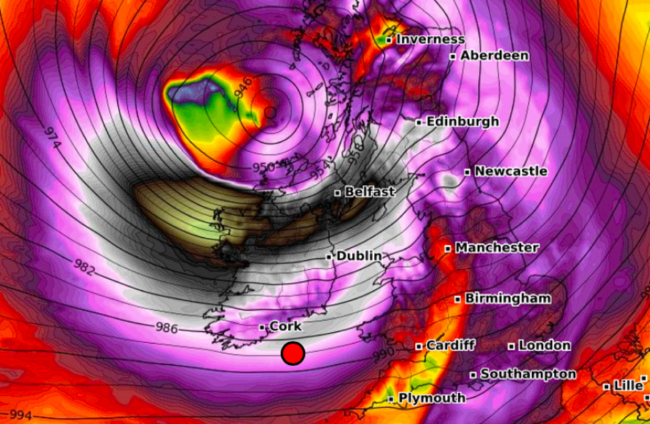
STORM ÉOWYN BROUGHT maximum gust speeds of 183km per hour to Ireland overnight, beating Ireland’s previous record gust speed from 1945.
The gust speeds of 183km per hour were recorded at Mace Head in Carna, in the Connemara area of Co Galway, while a gust speed of 159.8km per hour was recorded at Moneypoint in Co Clare. Average wind speeds at Mace Head were around 130km per hour as of 5am.
These kinds of wind speeds are as fast as some hurricanes.
On the Saffir-Simpson Hurricane Wind Scale, hurricanes with sustained wind speeds between 119 and 153km per hour are classified as Category 1 hurricanes.
However, Storm Éowyn is not technically a hurricane.
The reason why not has to do with how a storm first forms.
Storm Éowyn is a type of storm known as an “extratropical cyclone”.
Extratropical cyclones form in the ‘extra-tropics’ – that is, more than 30 degrees away from the equator, according to the UN Office for Disaster Risk Reduction.
A jet stream is often found relatively close by in the atmosphere, as is the case with Storm Éowyn. The strongest extratropical cyclones tend to occur in the winter months when the jet stream is at its strongest.
Hurricanes, however, are tropical storms that form over the North Atlantic Ocean and Northeast Pacific.
The tropical latitudes cover 23.5 degrees north and south of the equator, between the Tropic of Cancer and Tropic of Capricorn, whereas extratropical storms form further away from the equator.
That means that even though Storm Éowyn has brought wind speeds similar to some hurricanes, it does not meet the technical definition of a hurricane because of where it was formed.
Dr Nicholas Leach of the Predictability of Weather and Climate research group at the University of Oxford has said that “Éowyn is an extratropical cyclone that has formed in the North Atlantic”.
“Storms like Éowyn typically form along the boundaries between high and low atmospheric temperatures, in this case along a cold front in the North Atlantic,” Dr Leech said in a statement.
“The cold air behind the front sinks, forcing the warm air to rise. The displacement of the warm air creates a low pressure center, drawing more air in,” he said.
“Feedbacks from air temperature and humidity gradients further fuel the intensification of the low pressure system and associated high winds and precipitation.
“Éowyn looks like an archetypal extratropical winter storm based on how it has formed out of a cold front in the North Atlantic.”

To embed this post, copy the code below on your site


have your say