Sign in. It’s quick, free and it’s up to you.
An account is an optional way to support the work we do. Find out more.
Sign in. It’s quick, free and it’s up to you.
An account is an optional way to support the work we do. Find out more.
LAST UPDATE | 29 Oct 2025
MET ÉIREANN HAS issued Status Yellow weather warnings for six counties tomorrow, while Hurricane Melissa may cause more wet and windy conditions next week as the remnants of the storm are forecast to hit Ireland on Monday.
Counties Cork and Kerry are under a rain warning from 11am to 8pm tomorrow, while counties Galway and Mayo are under the same warning from 12pm to 8pm.
Locals should expect spells of heavy rain which could cause localised flooding, difficult travel conditions and poor visibility.
The two counties are also under a wind warning, alongside counties Waterford and Wexford, from 11am to 11pm tomorrow.
The national forecaster has warned that there will be very strong and gusty southerly winds with gales on coasts, which could cause difficult travel conditions, fallen trees and large waves.
Meanwhile, in Northern Ireland, a Yellow wind warning has been issued for counties Antrim, Armagh, Down, Fermanagh, Tyrone and Derry.
The warning is in place from 1pm to 11pm tomorrow. Strong winds and heavy rain should be expected.
Hurricane Melissa has caused widespread destruction in Jamaica as one of the most powerful hurricanes on record there.
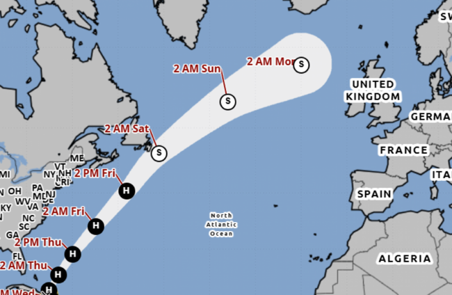
A map from the National Oceanic and Atmospheric Administration predicting the path of the hurricane shows that it may come quite close to Ireland.
Met Éireann meteorologist Linda Hughes said “the remnants of the hurricane are forecast to move in our direction on Monday” – but Ireland isn’t in for hurricane conditions.
Speaking to The Journal she said the storm will lose hurricane status in the West Atlantic where it is forecast to become a tropical storm.
Although it is still quite far away she said it will potentially cause “wet and windy weather” on Monday. The Northwest of the country will likely take the brunt of the weather.
Today will continue to be a breezy day with sunny spells and scattered showers which are expected to ease off towards the evening.
It’s expected to remain cool with highest temperatures of nine to 12 degrees.
It will be a cold but mainly dry and calm night with some showers in northern areas.
Lowest temperatures of one to four degrees.
Rain and drizzle will begin in Munster tomorrow morning, with wet and windy weather quickly extending.
Heavy rain is expected throughout the day, leading to localised flooding. Hailstones and isolated thunderstorms can also be expected, especially for southwest areas.

To embed this post, copy the code below on your site















have your say