Sign in. It’s quick, free and it’s up to you.
An account is an optional way to support the work we do. Find out more.
Sign in. It’s quick, free and it’s up to you.
An account is an optional way to support the work we do. Find out more.
LAST UPDATE | 18 Feb 2020
IT’S BEEN VERY wet over the past week with rainfall totals between 2.5 and 4 times the normal weekly rainfall amounts for this time of year, Met Éireann has said.
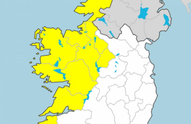
A Status Yellow rainfall warning has also been issued this morning for Connacht, Longford, Donegal, Clare and Kerry. It will be in place from 4am tomorrow until 4am on Thursday.
Tomorrow will be very windy, with occasional rain that will be heavy and possibly thundery at times.
There will be heavy rain tomorrow into the night. Localised flooding is likely as the ground is already saturated and river levels are elevated.
Looking further ahead, the forecaster predicted changeable and unsettled weather continuing for the rest of the week and over the coming weekend.
It said: “It will be a very wet week overall, especially in the northwest. Average rainfall amounts will be about 4 times the average countrywide.”
There are fears that parts of the midlands could be at risk of flooding in the coming days, with west Munster, Connacht and west Ulster.
Met Éireann said that Thursday will also be a cold, windy day with showers that could feature hail and a risk of thunder.
It added for Friday: “Wet and very windy, with occasional rain, heavy in places, with a risk of flooding, especially in Connacht and west Ulster.”

To embed this post, copy the code below on your site















have your say