Sign in. It’s quick, free and it’s up to you.
An account is an optional way to support the work we do. Find out more.
Sign in. It’s quick, free and it’s up to you.
An account is an optional way to support the work we do. Find out more.
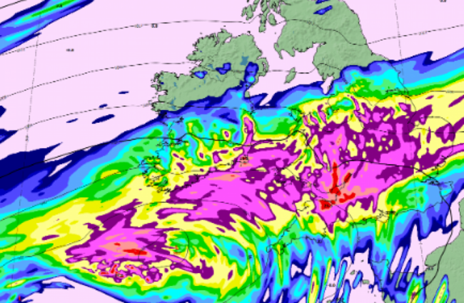
MET ÉIREANN HAS said that the heavy rain Ireland is getting due to Storm Claudia has a greater risk of flooding because of saturated ground, swollen rivers and ‘packed up’ rain.
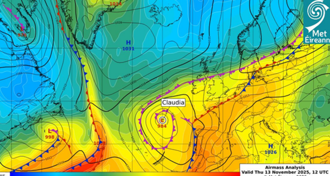
The forecaster said Storm Claudia, which was named by the Spanish weather service, has been impacting Ireland’s weather all week by “feeding weather fronts northwards over the country”.
The storm caused significant wind and rain in the Canary Islands and is currently making its way to England and Wales which are also under weather warnings.
A associated weather front over Ireland is at its height today, travelling north over southern and eastern parts.
“This frontal zone is expected to stall or ‘get stuck’ over us as the area of high pressure coming from Greenland moves closer to us,” Met Éireann says.
The national forecaster has said the volume of rain assocoated with the weather front is particularly noteworthy because it is taking place after a period of heavy rain, meaning the latest preciptation “will fall on saturated grounds and over swollen rivers”.
Coupled with the rain, windy weather is expected to allow the rain to ‘pack up’, or intensify, against the high ground in counties on the east coast.
Meteorologist Liz Walsh said: “It’s going to rain a lot over parts of Leinster and Munster [today] while it’ll stay largely dry for many parts of Connacht and Ulster.”
“This rain is brought to us by a weather front derived from Storm Claudia, named earlier in the week by the Spanish met service, and it will fall on already saturated ground and swollen rivers, intensifying the likelihood of significant flooding across Leinster and Munster.”
She said the “large accumulations of rain” are what caused an orange rain warning to be issued.
“We ask people to be cautious, avoid unnecessary travel as it can be hazardous and with poor visibility, and to stay updated on our website or app, signing up to warnings notifications,” she added.
Met Éireann said that weather warnings may be updated as the weather progresses.
The forecaster emphasised the possibility of significant flooding – which may even happen in counties unaffected by alerts.
“River and surface water flooding is expected in Leinster and Munster on Friday and into the weekend, in part due to the recent rainfall earlier this week which has led to saturated grounds and swollen rivers, combined with the upcoming heavy rainfall expected,” it said.
It warned that large rivers across Leinster and Munster may overflow banks, while smaller rivers and streams may flood more rapidly.
Drainage systems may be overwhelmed in urban areas due to the intense rain over a short period.
The public have been warned that there will be hazardous, dangerous travelling conditions especially in areas under orange warning. This may involve poor visibility and debris.
For tips on how to stay safe in the weather, visit the Government’s advice page on being winter ready.

To embed this post, copy the code below on your site















have your say