Sign in. It’s quick, free and it’s up to you.
An account is an optional way to support the work we do. Find out more.
Sign in. It’s quick, free and it’s up to you.
An account is an optional way to support the work we do. Find out more.
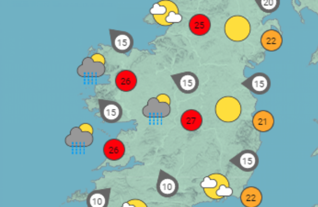
A STATUS YELLOW thunderstorm and rainfall warning for counties on the west coast has been issued by Met Éireann today.
The meteorological service said on Twitter that the thunderstorm and rainfall could cause possible local flooding, power outages and difficult travelling conditions in Clare, Cork, Kerry, Limerick, Tipperary, Galway and Mayo.
Met Éireann estimate that the counties, who are on a yellow warning, could experience slow-moving rainfall and thunderstorms with frequent lightning, gusty winds and hail in the most intense storms.
The yellow warning is in place from 1.00pm this afternoon until 9.00pm tonight.
⚠️Status Yellow - Thunderstorm and Rainfall warning for Clare, Cork, Kerry, Limerick, Tipperary, Galway, Mayo⚠️⛈️
— Met Éireann (@MetEireann) June 14, 2023
Possible Impacts:
• Localised flooding
• Difficult travelling conditions
• Power outages
Warning details ➡️https://t.co/Xg3aMJlyuS pic.twitter.com/MEu6q4tQNk
For the rest of the country, the weather is set to remain hot and humid today as yesterday proved to be the hottest day of the year, according to Met Éireann.
Temperatures today are predicted to rage from 22 to 27 degrees and “most areas will be dry with hazy sunshine,” the forecaster said.
The forecaster also warned that UV levels would be “moderate to high under cloudy skies, and high under clear skies.”
That said, “scattered heavy showers or thunderstorms will develop in the west and southwest this afternoon and evening,” the forecast read.
Met Éireann said there was a potential risk of hail and spot flooding in those areas.
Today was the warmest day of the year!🌞😎
— Met Éireann (@MetEireann) June 13, 2023
Our synoptic station at Oak Park in Co. Carlow reached 28.8°C, with numerous other stations right across the country seeing temperatures in excess of 25°C. pic.twitter.com/Hk8kbCB6fZ
Morning fog is expected to clear in most for the most part of the country but may linger in some coastal areas.
Warm & humid today🥵 with fog🌫️ mostly lifting this morning.
— Met Éireann (@MetEireann) June 14, 2023
Many areas will be dry with hazy sunshine⛅️ but heavy showers☔️ or thunderstorms⛈️ will develop in the W & SW later, with the potential for hail & spot flooding.
Highs🌡️ of 22 to 27°C, cooler along coasts. pic.twitter.com/iL4m8FarNH
You can read about how to stay safe and cool in the hot weather here.
Additional reporting by Muiris O’Cearbhaill

To embed this post, copy the code below on your site















have your say