Sign in. It’s quick, free and it’s up to you.
An account is an optional way to support the work we do. Find out more.
Sign in. It’s quick, free and it’s up to you.
An account is an optional way to support the work we do. Find out more.

LAST UPDATE | 2 Feb
TAOISEACH MICHEÁL MARTIN said the Government cannot “wave a magic wand and just deliver” flood relief schemes as he visited affected homes and businesses in Co Wexford.
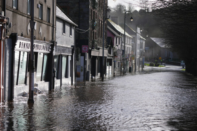
Martin met residents of Island Road, Enniscorthy, an area that was badly hit by flooding in recent weeks after the River Slaney burst its banks during Storm Chandra.
Storm Chandra left homes and businesses inundated with water, cars stranded, power cut and Enniscorthy town centre closed off after the River Slaney burst its banks.
The storm brought heavy rain last week on top of already sodden ground, which led to flooding across the country, particularly in Wexford.
Martin is expected to also visit parts of Carlow and Kilkenny today.
Speaking to reporters, Martin said it was “a soul-destroying experience to have your house flooded or your business flooded, and there has been a pattern here over many decades of flooding at this location”.
Asked if there was any way the Government could “expedite” flood relief schemes, Martin said planning routes “have to be gone through, there’s no question”.
He added: “We’ll do everything we can to speed up the progress of a scheme, going through the planning process and the design and development works itself.
“These are very comprehensive schemes. They are complex. I’m not going to try and pretend that we can wave a magic wand and just deliver them. That would be wrong to do.
“But what we can do, it’s a parallel approach, the interim measures, whilst doing everything we can to shave off time.”
Martin’s visit came as Met Éireann issued a Status Yellow warning for rain in Carlow, Cork, Kilkenny, Waterford and Wexford.
Met Éireann warns that further heavy rain falling on already saturated ground, combined with high river levels and high tides, will lead to localised flooding, river flooding and difficult travel conditions.
The alert will come into place from 9pm tonight and remain in place until 3pm tomorrow afternoon.
A separate Status Yellow warning meanwhile will come into place tomorrow morning at 6am across Dublin, Louth and Wicklow and remain in place until 9pm tomorrow.
Dublin City Council said it is monitoring river levels and coastal conditions closely.
It added that tidal warnings have prompted it to close carparks along coasts at Sandymount and Clontarf from 6am tomorrow as some wave overtopping may occur.
The cycle lane at Clontarf will also close as a precautionary measure, while Eden Quay Boardwalk (floodgates) will close mid-morning as a precautionary measure.
The flood gates along the River Dodder will also remain closed until further notice.
Dublin City Council added that it has a limited supply of sandbags at “strategic locations” and that these resources are deployed “where required, with priority given to critical infrastructure and locations assessed as being at immediate risk”.
Researchers from Met Éireann and the ICARUS climate research centre at Maynooth University last week carried out a “super rapid” analysis of the rainfall before and after Storm Chandra.
The researchers noted that while the one-day rainfall directly from the storm was “not particularly remarkable”, the seven-day accumulated rainfall “made an otherwise relatively uninteresting rainfall event far more devastating from a flooding perspective”.
The researchers added that this seven-day accumulated rainfall event has been made almost three times more likely due to climate change.
Enniscorthy in Co Wexford, where there have been nine major floods since 2000, was particularly badly hit.
Official data from the Office of Public Works showed that the Slaney almost equalled its record high water level of almost 4.7 metres, which it hit during the notorious 2000 flooding.
Meanwhile, the National Emergency Co-ordination Group (NECG) met again today to continue to prepare for the risk of further flooding.
It said response agencies are closely monitoring the situation, with heavy rain forecast for tonight, into tomorrow, and over the next few days.
As a result, further flooding is likely along rivers and in coastal areas.
The NECG said all relevant authorities have been on alert and focused on putting in place measures to mitigate the impact of further rain and to ensure readiness to respond to any flooding incidents.
The NECG meanwhile noted that alongside the two Status Yellow alerts, a weather advisory is also in place.
Spells of heavy and persistent rainfall will continue throughout this week, particularly in southern and eastern coastal counties.
The NECG urged the public to “be alert for flooding as the situation can change very quickly and even small amounts of rain could result in significant impacts in areas where river levels are high and/or where the ground is already saturated”.
Tánaiste Simon Harris said yesterday that the government was “responding in real time with financial assistance. I think people want that. I think people expect it. I think that’s absolutely right”.
The Minister for Finance went on to say that “it’s not just about writing cheques after the flood”, adding that people also want to know what the government will do to prevent flooding.
“We’ve seen a lot of good flood relief skills put in place that have made a huge difference, but there are too many towns that many are waiting too long, and Enniscorthy is the obvious example this time,” he said.
-With additional reporting from Diarmuid Pepper

To embed this post, copy the code below on your site













have your say