Sign in. It’s quick, free and it’s up to you.
An account is an optional way to support the work we do. Find out more.
Sign in. It’s quick, free and it’s up to you.
An account is an optional way to support the work we do. Find out more.
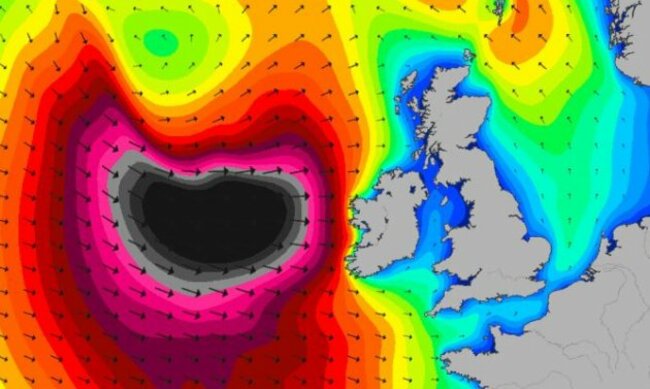
The predicted swell of the Atlantic coast in the early hours of Saturday [Magic Seaweed]
MET ÉIREANN’S ISSUED another of it’s ‘orange alert’ storm warnings this morning — and this weather system looks a little more serious than the one that hit last weekend.
Winds of up to 130km are set to sweep into the West from Friday night — and in addition to the high-tide factor which created an extra risk of flooding last Saturday and Sunday, the weather service says we can also expect frequent heavy showers, including “some thundery with sleet and snow”.
Precautions are being put in place on exposed coasts as forecasters warn of “extremely high waves”:
High coastal flood risk too due to the combination of very high spring tides, extremely high waves (greater than 10 m), low pressure and onshore winds – southwest, west and northwest margins most at threat.
The current ‘orange’ wind warning applies to Munster, Connacht and Donegal — but the rest of the country isn’t expected to escape the effects of the weather system.

To embed this post, copy the code below on your site














have your say