Sign in. It’s quick, free and it’s up to you.
An account is an optional way to support the work we do. Find out more.
Sign in. It’s quick, free and it’s up to you.
An account is an optional way to support the work we do. Find out more.
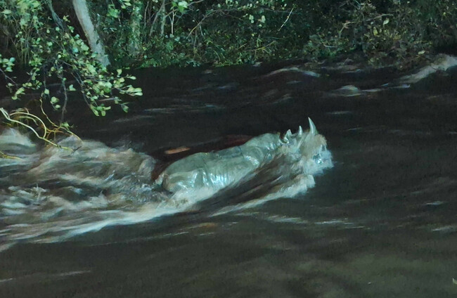
LAST UPDATE | 14 Nov 2025
THE RAIN IS still pouring down across much of the country this evening as a number of weather warnings remain in place for much of the east and south.
Met Éireann has warned of potential significant flooding and difficult travel conditions as a result of the heavy rain.
Flights have been cancelled at Dublin Airport and flooding has been reported in Offaly and Laois, while there have been several fallen trees in Wicklow and Wexford.
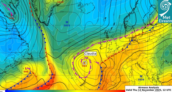
The intense rain is due to Storm Claudia, a Spanish-named storm that started its life bringing strong rain and wind to Spain and Portugal.
The National Directorate for Fire and Emergency Management convened yesterday to prepare for the poor weather and potential impacts like flooding.
The Road Safety Authority has urged road users to be cautious while travelling, with disruption and delays for drivers and public transport users likely as the evening progresses.
Updates by David Mac Redmond (now), Jane Moore, Eoghan Dalton, Diarmuid Pepper and Lauren Boland (earlier).
Good morning. It’s a wet one out there for much of the country – it’s a day for staying inside, or at least bringing a solid raincoat with you if you have to venture out.
The poor weather is expected to persist throughout the day and be rough overnight as well into tomorrow morning.
We’ll have live updates here on The Journal about the weather and its impacts.
Met Éireann has issued several weather warnings for the coming hours. Here’s exactly what they are:
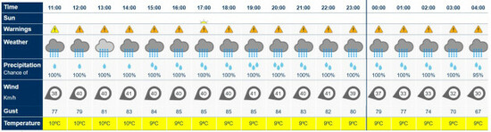
How often do you see a 100% chance of rain forecast for the entire day?
Here’s what Met Éireann’s forecast looks like for Dublin city.
The good news is it drops to a mere 95% at 4am. Hang in there.
Met Éireann has said that heavy rain on ‘saturated ground’ is why it’s concerned about Storm Claudia.
The volume of rain and the length of time it will go on will cause saturated grounds and swollen rivers, the national forecaster has explained.
Significant flooding could potentially happen even in counties that haven’t received a weather warning.
Read the full story here on how the storm is affecting Ireland.
Met Éireann forecaster Liz Walsh has said that the effects of the rain will likely build up over the next few days.
Speaking on RTÉ’s Today with David McCullagh, she said that “certain things like swollen rivers, they have differing reaction times”.
“Some are eight hours, some are 20 hours, some are three days,” she said.
She said that means the impacts from the rain could be felt “for a number of days afterwards”.
The Road Safety Authority is urging road users to take extra care on the roads, especially in the east and south of the country.
The RSA is advising that drivers need to slow down and allow a greater braking distance than usual between themselves and the vehicle in front.
This is especially important on high speed roads, such as dual carriageways and motorways, where there is increased danger of aquaplaning.
The RSA has also reminded motorists that flooded roads that appear shallow could be deeper than you think and that fallen trees or branches may not be immediately visible.
All train services are currently operating as normal despite the weather, according to Irish Rail.
If that changes, it will notify customers on its website.
It’s recommending that passengers allow extra time to get to stations.
While waiting in a station, passengers should stand back from platform edges in high wind conditions, especially in exposed coastal areas, until the train has come to a stop.

Local authorities and several government departments, state agencies and utility providers met again this morning to prepare for impacts of rain and flooding.
The meeting of the National Directorate for Fire & Emergency Management (NDFEM) noted that the predicted rainfall over the next 24 hours brings a high risk of flooding in many counties.
In a statement after the meeting, the NDFEM said that flooding is a risk for all areas due to the current conditions, and even counties with a yellow rain warning or no rain warning will remain at risk of flooding.
“Local authorities and Transport Infrastructure Ireland will be active and responding to the affected areas; however, the need may arise to close some roads due to flooding, and all motorists should follow any traffic instructions put in place,” it said.
“Driving during heavy rain is a significant risk, and motorists should take considerable care when travelling, remaining conscious of the road conditions at all times.”
And here’s a message from Keith Leonard, National Director of the NDEFM:
“It’s important that people are aware of the potential conditions in their area. River and surface water flooding is expected in Leinster and Munster today and into the weekend, in part due to the recent rainfall earlier this week, which has led to saturated grounds and swollen rivers, combined with the heavy rainfall we are expecting.
“We are asking people to stay away from coastal areas during this period, avoid open riverbanks and canal paths in flood conditions, and to stay away from swollen rivers, streams and flooded riverbanks, where banks can collapse without warning. Flooding impacts can be very localised and specific, so be sure to heed any advice issued by the emergency services and your local authority.
“Drivers also need to be wary of potentially hazardous conditions in their area, so please slow down, increase your stopping distances and watch for surface water and debris on roads. If the road ahead is flooded, do not enter – turn around and find another route.”
The NDFEM has shared the following public safety advice amid the bad weather:
Coincidence or strategic timing? While we’re all stuck inside, RTÉ has dropped a trailer for The Late Late Toy Show, which is on the first Friday of December.
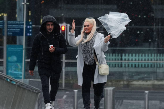
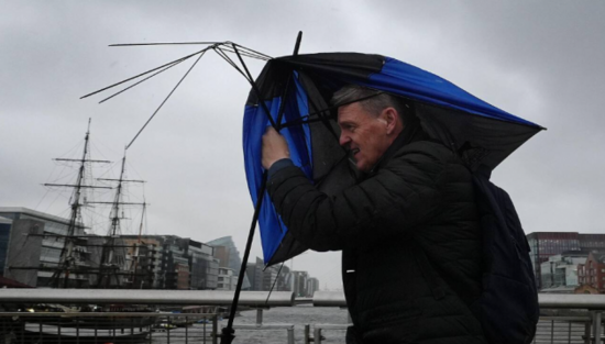
A plight that will no doubt hit many of us today: our reporter Sophie Finn’s umbrella is no more after being faced with the outdoors.
Despite the wet weather, operations are said to be “moving well” at Dublin Aiport.
As of 12 noon, a spokesperson said the airport has seen one incoming aircraft perform a go-around, but other than that, departures and arrivals are moving smoothly and this is expected to continue for the rest of the day.
However, the spokesperson noted that heavy rain could make for tricky driving conditions.
“Passengers should give themselves plenty of time to get here and take extra care on the roads,” said the Dublin Airport spokesperson.
“Passengers seeking updates on specific flights should contact their airline directly.”
The HSE has urged people, if they can do so, to phone older or vulnerable neighbours to check that they are okay.
However, it has added that people should “heed public warnings and do not put yourself at risk”.
As wind and heavy rain continues across the country, if you can, phone older or vulnerable neighbours to check that they are OK. Please heed public warnings and do not put yourself at risk. For updates see @MetEireann https://t.co/ZmmGlcp5fR https://t.co/upy64SxGNV
— HSE Ireland (@HSELive) November 14, 2025
While Louth is under a Status Yellow rain warning, it has been warned that all areas are at risk of flooding.
As a result, sandbags are available from a number of council locations throughout the county.
⚠️ Weather Alert: Sandbags Available for Collection ⚠️
— Louth County Council (@louthcoco) November 13, 2025
Localised flooding is expected in County Louth over the coming days due to a combination of high tides and persistent heavy rain. River flooding, particularly in high ground areas, poses a significant risk from Friday… pic.twitter.com/scA7pzgApF
Keith Leonard, national director for the National Directorate for Fire & Emergency Management, has told RTÉ’s News at One that while there will be some “very difficult conditions”, local authorities have been “preparing for this for the last number of days”.
He also warned that “the flooding could lag and still come through after the rainfall has gone”.
Leonard also said fallen leaves is a “complicating factor”.
“But local authorities have been checking culverts, gullies and drains, trying to make sure, as much as possible, that they can unblock them and allow surface water to run off as quickly as we can.”
He also warned off road hazards due to the heavy rain.
“We know what the M50 is like on the best of conditions and that gets much worse anytime there’s significant rainfall.
“For people who have to travel, particularly people trying to get to the airport or other urgent things, you really need to give yourself a good bit of extra time over the next few days to make those journeys.”
All Dublin City Council Parks are now closed as a result of the Status Orange weather warning and will reopen tomorrow at 11am.
Please note that due to the Status Orange and Yellow weather warnings in place for the Dublin region, Dublin City Council Parks will be closed from 12pm Friday 14th November 2025 until 11am Saturday 15th November 2025.
— Dublin City Council (@DubCityCouncil) November 14, 2025
This will affect all facilities, events and activities in…
In a note sent to Dublin councillors, it was noted that Dublin City Council’s flood response teams have been deployed since 4am this morning.
Higher rainfall in in the Dublin Mountains could also impact rivers to the south of the city and as a result, teams are actively tracking flows on the Dodder, Camac and Poddle.
It’s also been warned that the River Dodder requires “particular vigilance” over the weekend and flood defence gates are in place.
The note to councillors also warned that falling leaves are impacting on drainage and that sandbags are ready to be deployed “promptly” should the situation escalate.
Meanwhile, Dublin Fire Brigade were hard at work yesterday to ensure all its flood response equipment is up to scratch should the need to use it arise.
In preparation for the status Orange, rain warning tomorrow, Firefighter/Paramedics in Phibsborough have checked all of their flood response equipment. pic.twitter.com/1r4Nzsmgtx
— Dublin Fire Brigade (@DubFireBrigade) November 13, 2025
In Co Wicklow, a fallen tree has closed the R412 affecting Loughmogue, Dunlavin and Drim Rathdangan.
Crews are working to clear the tree, near the county boundary with Kildare.
⚠️ Notice of Fallen Tree ⚠️
— Wicklow County Council (@wicklowcoco) November 14, 2025
R412 Loughmogue, Dunlavin and Drim Rathdangan.
Tree removal in process.
Road Closed until tree is removed.#Wicklow #WeatherWarning #BaltinglassMD pic.twitter.com/HZg5D7ZXF7
While the south and east of the country is now subject to heavy rain, the North is due to feel its impact overnight.
From midnight until 12 noon tomorrow, counties Armagh and Down will be under a yellow alert for rain.
Video from the Dún Laoghaire Coast Guard of sea conditions in Scotsman Bay, alongside a message from the Coast Guard to stay out of the water during the storm.
Sea conditions in Scotsman Bay, Dun Laoghaire. Stay out of the water during #stormclaudia @MetEireann @IrishCoastGuard @rtenews pic.twitter.com/qne9umNgal
— Dun Laoghaire Coast Guard (@DLCoastGuard) November 14, 2025
Laois isn’t under a weather warning, but is hasn’t been spared from the rain, as can be seen from these images in Portarlington.
The River Barrow at People's Park Portarlington this morning ~ Need a boat to get to the seats @LaoisNews @LaoisToday @LaoisPeople1 @LaoisCouncil #HeartofIreland pic.twitter.com/qrEZvKM4N7
— mary collins dempsey (@CollinsDempsey) November 14, 2025
There are some fallen trees in Wicklow, as well as roads which are closed due to flooding.
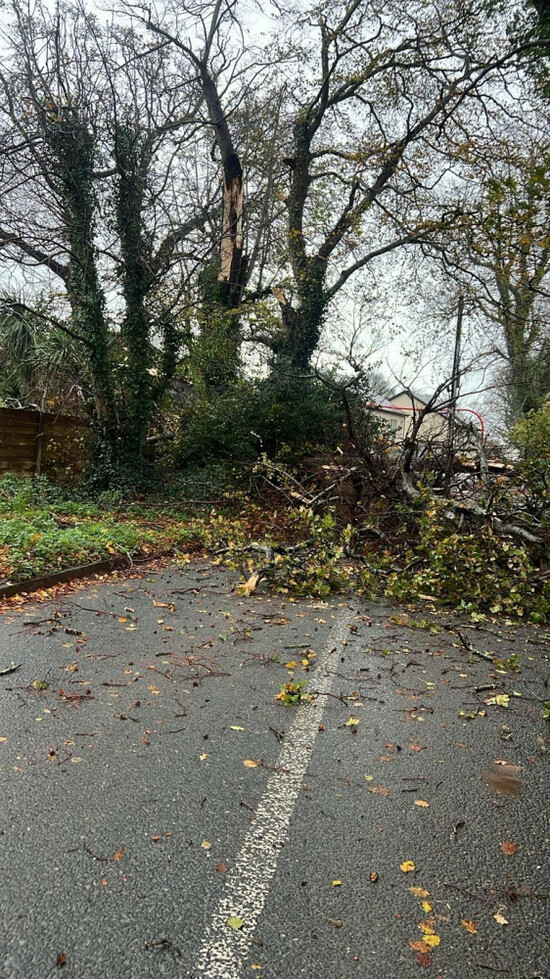
⚠️ Wicklow County Council wish to advise that a Section of the R750 (Sea Road), Arklow at Porters Bridge is temporarily closed till further notice due to Flooding.
— Wicklow County Council (@wicklowcoco) November 14, 2025
Please use alternative routes#Wicklow #WeatherWarning #ArklowMD pic.twitter.com/sKzVmKhdYf
In the past half hour, Met Éireann has issued this advice to people.
It notes that flooding is to be expected in Leinster and Munster and warned that heavy rainfall could “overwhelm urban drainage systems”.
The Public is advised to stay awat from swollen rivers and streams and to stay awya from coastal areas.
‼️With a Status Orange Rain⚠️Yellow Rain & Wind warnings in most of Munster & parts of Leinster for the rest of today & into tomorrow, please be aware of potential impacts & pay heed to the #SafetyAdvice provided & check in with your local authorities for further guidance⬇️ pic.twitter.com/SjkcYjWw7U
— Met Éireann (@MetEireann) November 14, 2025
And here’s the update from Alan O’Reilly of Carlow Weather as of 3pm.
He says over 36mm of rain has fallen on the eastern side of the Wicklow Mountains and “plenty of rain falling in the south”, with more to come this evening and overnight.
“The good news is, sunny spells from the north will extend down the country on Sunday and by late afternoon should have extended to most areas.”
He also forecasts sunny spells next week but a drop in temperatures.
3pm Friday brief update pic.twitter.com/rIMJuWzusM
— Carlow Weather (@CarlowWeather) November 14, 2025
Dublin City Council says all its flood response teams are “active and ready”.
It’s also appealed to the public to park safely to avoid blocking drains so that maintenance staff can have access.
Dublin City Council is actively responding to an Orange Weather Warning for heavy rainfall currently in effect for Dublin
— Dublin City Council (@DubCityCouncil) November 14, 2025
• Our operational teams have been preparing and now monitoring the rainfall which is currently within our thresholds to competently manage – all flood… pic.twitter.com/DHz3RterOi
In Dún Laoghaire, the East and West Pier closed at 2pm due to the flooding risk.
Its recycling centres also closed from 2pm due to the weather warning.
The European Commission’s Copernicus Emergency Management Service has noted that severe weather and flood impacts are expected as Storm Claudia passes over Ireland.
Its mapping team has been requested to provide flood extent and damage assessment emergency mapping.
🌀 #EMSR849 – Storm in Ireland🇮🇪
— Copernicus EMS (@CopernicusEMS) November 14, 2025
Severe weather and flood impacts are expected as Storm Claudia passes over Ireland.
Our #MappingTeam is requested to provide flood extent and damage assessment emergency mapping.
🔗https://t.co/lT3ErNiymU pic.twitter.com/BklS8SfuaF
Gardaí are urging people to stay safe amid the flood warnings.
With Status Orange and Yellow rain warnings now declared in many parts of the country, we encourage you all to take a read of our advice on what to do if you are at risk of flooding in your area.
— An Garda Síochána (@GardaTraffic) November 14, 2025
Stay Alert, Stay Safe. https://t.co/lBloWh1Bfy pic.twitter.com/1eG8iV55tL
It’s wet and windy in Dublin and some people are unfortunately being let down by their umbrellas.

Here’s how things looked this morning along the Avoca River in Arklow, Co Wicklow.
Stormy conditions seen along the Avoca River in Arklow, Co Wicklow, this morning ahead of a Status Orange rain warning coming into effect. The warning for Wicklow, Wexford and Dublin comes into effect at midday | Follow live https://t.co/B4cbMMaPXn pic.twitter.com/RpSIfU1Ldi
— RTÉ News (@rtenews) November 14, 2025
DAA spokesperson Graeme McQueen has told RTÉ’s Drivetime that eight Emerald Airlines flights have been cancelled at Dublin Airport in the last few minutes.
“They’ve cancelled four in, four out,” he said, adding that the destinations were Leeds, Bradford and Birmingham.
“That’s due to crosswinds. They’re just concerned about wind speeds. The planes that operate those routes are ATRs – now to everyone, that would mean propeller-type aircraft.”
McQueen said that while things are “pretty trudgy” on the airfield, things are moving well at Dublin Airport.
“If you are flying tonight, we would recommend you stay in touch with your airline just to make sure you’re up to date on any delays or issues. We’re expecting a full schedule tonight, albeit you may have some little delays along the way,” he added.
Rain? Or Ronaldo’s tears?!
— Dublin Airport (@DublinAirport) November 14, 2025
🤭 pic.twitter.com/46lx7mMWNy
For anyone who has to brave the weather to get a train in the next while, Iarnród Éireann’s Barry Kenny has said that all services are operating on all routes without disruption.
“We don’t have any weather impacts at this point in time,” he told RTÉ’s Drivetime.
Crews are located right across the network who ready to respond to any issues that arise. “We would ask customers for their patience if any weather-related disruption occurs,” he added.
Dublin City Council is reminding the public that all of its parks will be closed until 11am tomorrow.
They said that any scheduled activities should not take place and members of the public should avoid entering parks until the weather warnings have expired.
Please note that due to the Status Orange and Yellow weather warnings in place for the Dublin region, Dublin City Council Parks will be closed from 2pm Friday 14th November 2025 until 11am Saturday 15th November 2025.
— Dublin City Council (@DubCityCouncil) November 14, 2025
This will affect all facilities, events and activities in… pic.twitter.com/mjRWyxxiQ7
Powerscourt Waterfall in Co Wicklow is flowing strongly amid the stormy weather.
Friday evening @ Powerscourt Waterfall pic.twitter.com/UrW5sogaXH
— Powerscourt Estate (@thepowerscourt) November 14, 2025
A tree has fallen and blocked the Ashford to Roundwood Road in Co Wicklow.
Wicklow County Council are asking the public to take an alternative route until it is cleared.
⚠️ Notice of Fallen Tree ⚠️
— Wicklow County Council (@wicklowcoco) November 14, 2025
Wicklow County Council would like to advise the public that a tree has fallen and blocked the Ashford to Roundwood Road.
Please use alternative route until cleared.#WicklowCountyCouncil #WeatherWarning #Orange #WicklowMD pic.twitter.com/vXyobcCmt4
Meanwhile, this tree that fell on Drummin Lane in Co Wicklow earlier has been removed.
❗ UPDATE: Tree has been removed.❗
— Wicklow County Council (@wicklowcoco) November 14, 2025
⚠️ Notice of Fallen Tree ⚠️
Wicklow County Council would like to advice the public of a fallen tree on Drummin Lane, Drummin East.
Clearance is currently underway.#WicklowCountyCouncil #WeatherWarning #Orange #Greystones pic.twitter.com/0wjdwohBuj
#FloodUpdates #Offaly
— Offaly County Council (@offalycoco) November 14, 2025
⚠️N62 Birr side of the Black Bull. Significant surface water remains. Signage is in place.
⚠️Botley Lane, Portarlington is closed and likely to remain closed over the weekend.
Signage is in place. pic.twitter.com/IeV4kN8PpU
Offaly County Council has said that although county is not included in the Met Éireann weather warnings, given existing soil saturation, surface water runoff from high ground, standing water in low-lying areas and elevated river levels, they are continually monitoring the situation.
In a statement to RTÉ’s Drivetime, the council said road crews have been mobilised from earlier this week “for both mitigation and reactive responses in a number of locations throughout the county.
“Crews have responded to localised roads flooding issues in Tullamore, Edenderry (Portarlington) and Birr municipal districts,” the statement read.
Keith Leonard, national director for the National Directorate for Fire & Emergency Management, has told RTÉ’s Drivetime that Wexford and areas of South Wicklow are experiencing “some surface flooding” at this point.
Leonard said there is surface flooding “really right across the south and the eastern region”, which will cause disruption to road networks across a fairly wide area in Leinster and Munster.
He said that while the weather warnings will expire tomorrow morning, oftentimes the flooding – particularly in bigger catchments areas – lags a little bit behind the actual rainfall itself.
“We could see flooding right across the weekend, right into Sunday.”
Leonard said the NDFEM is watching the River Slaney “very closely”, with the Shannon “also starting to come to a very high level”.
Gardaí are advising drivers in Dublin to avoid the East-Link Toll Bridge due to fallen debris.
⚠ TRAFFIC INFORMATION ⚠
— An Garda Síochána (@GardaTraffic) November 14, 2025
Due to debris caused by Storm Claudia, Motorists are advised to avoid the Tom Clarke Bridge / East-Link Toll Bridge on the North Quays of Dublin City.
Delays are expected if travelling in the area. pic.twitter.com/XtPGbu3ov1
Wicklow County Council are reporting “limited localised flooding” which is likely to continue throughout the evening as a result of the continuing rainfall.
ORANGE WARNING - LATEST UPDATE:
— Wicklow County Council (@wicklowcoco) November 14, 2025
Wicklow County Council crews are continuing to respond to reports of fallen trees across the county, these are being dealt with as appropriate.
Whilst the situation is evolving, there has been limited localised flooding and this is likely to… pic.twitter.com/9Du3BhwB9H
Dublin City Council has warned of the need for “extra vigilance” by the River Dodder as heavy rainfall continues.
Dublin City Council is actively responding to an Orange Weather Warning for heavy rainfall currently in effect for Dublin
— Dublin City Council (@DubCityCouncil) November 14, 2025
• Our operational teams have been preparing and now monitoring the rainfall which is currently within our thresholds to competently manage – all flood… pic.twitter.com/OkyRHHLu5N
Heavy rain isn’t the only concern in Dublin.
Dublin Fire Brigade were called to the Point Village this evening after high winds caused damage to a building.
#StormClaudia
— Dublin Fire Brigade (@DubFireBrigade) November 14, 2025
Firefighters have made a scene safe at the Point Village. A window affected by high winds fell and damaged cladding on a building.
There were temporary traffic restrictions in place on approach to @DublinTunnel pic.twitter.com/1KlJmtdMmD
Hello, David Mac Redmond here taking over after venturing down to the Dodder in Milltown, where the river is very high this evening.
The Dodder River is very high this evening in Milltown in Dublin. @thejournal_ie pic.twitter.com/GDuwu9Go8V
— David Mac Redmond (@DavidMacRedmond) November 14, 2025
These paths along the river often get flooded in heavy rain. pic.twitter.com/hjByTJ75Hq
— David Mac Redmond (@DavidMacRedmond) November 14, 2025
Met Éireann’s Gerry Murphy has told RTÉ’s Six One News that the rain in the east is going to be at its heaviest from now on and into the night.
“So there are places in the east which have already had plenty of rain,” Murphy said, “but they’re going to notice that the rain will increase in intensity over the coming hours, and that rain will be heavy, really, up until about 11 o’clock, possibly midnight.”
❗UPDATE Tree has been removed ❗
— Wicklow County Council (@wicklowcoco) November 14, 2025
⚠️ Notice of Fallen Tree ⚠️
Wicklow County Council would like to advise the public that a tree has fallen and blocked the Ashford to Roundwood Road.
Please use alternative route until cleared.#WicklowCountyCouncil #WeatherWarning #Orange… pic.twitter.com/ENKVuTbwcI
Please be advised that all rowing sessions at the Dublin Municipal Rowing Centre have been canceled due to unfavorable weather conditions.
— Dublin City Council (@DubCityCouncil) November 14, 2025
The astro pitches at Ballyfermot Sports & Fitness will be closed this evening until the Orange Weather Warning is lifted.
Additionally,… pic.twitter.com/vzjDTM7agP
As of 5pm, there was only a small amount of disruption at Dublin Airport.
Emerald Airlines made the decision this evening to cancel eight flights (four inbound and four outbound) scheduled to operate between Dublin and Birmingham and Leeds Bradford airports.
This was because crosswind speeds at both airports were expected to exceed safe operating levels for the type of aircraft used on these routes.
There have been a small number of go-arounds over the course of the day also.
While wet and windy weather is expected to continue through the evening and into Saturday morning, Dublin Airport expects to operate close to a full schedule.
Passengers due to fly over the next 24 hours should contact their airline directly for latest updates and take extra care on the roads leading to and from the airport.
While the wet and windy weather has caused disruption across the country, the Corkmas parade, the official start of Christmas in Cork city, is underway this evening.
Cork City Council decided to go ahead with the parade in the city centre because a large number of the performers had been booked for several months
“Rain doesn’t bother Santa on Christmas Eve and it won’t bother him tonight either,” added a spokesperson.
The parade started at 7pm and features dancers, marching bands and performers.
A rugby match at Virgin Media Park at 7.30pm is also likely to add to traffic congestion on some routes into the city.

That rain continues and getting heavier pic.twitter.com/UTQ3qXUKeq
— Carlow Weather (@CarlowWeather) November 14, 2025
Video footage here of Powerscourt Waterfall in Co Wicklow, which is under a Status Orange warning.
Friday evening @ Powerscourt Waterfall pic.twitter.com/UrW5sogaXH
— Powerscourt Estate (@thepowerscourt) November 14, 2025
Met Éireann’s Meteorologist Mark Bowe outlines what we can expect tonight and over the coming days.
He says the rain will continue overnight and into the morning, before easing later tomorrow.
🎙️Hear the latest National Weather Forecast with Meteorologist Mark Bowe for tonight and the coming days⬇️ pic.twitter.com/7ZCMHEmj1c
— Met Éireann (@MetEireann) November 14, 2025
#StormClaudia Update
— Dublin Fire Brigade (@DubFireBrigade) November 14, 2025
Firefighters are currently attending....
🌳 Ridgewood Grove Swords - tree down
🏠 Dalkey - flood water in a house
🌳 Malahide Road near Circle K, tree down on cables, bus lane blocked pic.twitter.com/EiKJX2BbSn
The rain and wind are still lashing the east of the country in particular tonight. The heaviest rainfall is expected to continue until sometime between 11pm and midnight.
Here are the main things you need to know:

To embed this post, copy the code below on your site

















have your say