Sign in. It’s quick, free and it’s up to you.
An account is an optional way to support the work we do. Find out more.
Sign in. It’s quick, free and it’s up to you.
An account is an optional way to support the work we do. Find out more.
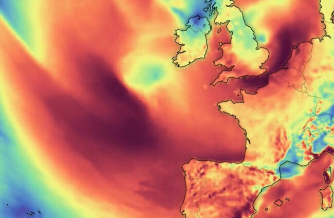
MUCH OF NORTHWESTERN Europe went on high alert today as a storm dubbed Ciarán threatens to bring gale-force winds and extreme rainfall to the region.
Newry in Co Down was subjected to “biblical” flooding yesterday, along with similar scenes in Co Louth.
Later today, counties Cork, Waterford, Carlow, Kilkenny, Wexford and Wicklow are to fall under a Status Yellow rain warning.
Further afield, three French departments – Finistere, Cotes-d’Armor and Manche – will be placed on red storm alert, the highest level, at midnight (23:00 Irish time), national weather agency Meteo-France said.
Two of them will also be placed on maximum flood alert, it added.
A total of 17 departments along the French coast, from the Gironde region to the northern Hauts de France, will be on the lower category orange alert.
In Britain, the meteorological office said there would be bursts of heavy rain, a risk of flooding in some areas and gusts of 60-70 miles per hour along England’s south coast.
In France, the storm was even expected to unleash winds of up to 170 kilometres per hour, notably on the coastlines of Brittany and Normandy in the northwest, Meteo-France forecaster Francois Gourand warned yesterday.
🔴 3 départements en Rouge
— VigiMétéoFrance (@VigiMeteoFrance) November 1, 2023
🔶 17 départements en Orange pic.twitter.com/Dlqr2YsFxR
Rainfall could reach 50 millimetres within just six hours in those areas, the weather agency said.
Ciarán is expected to hit Brittany before midnight, with winds of up to 150 kmph on the coast, and 130 kmph inland with a second, more violent, storm phase following some hours later.
Some 3,200 firefighters will be deployed in the most vulnerable areas, the French interior ministry said.
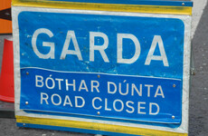
The authorities, warning of falling trees and blocked roads, have urged people to remain indoors if possible and stay away from the coast.
National rail operator SNCF has stopped regional trains in the most affected areas, and also cancelled a number of high-speed TGV rail services.
Eurostar, expecting disruptions and slowdowns, told AFP it was recommending that passengers delay their trips planned for Thursday.
The airport in Brest, western Brittany, will be closed from late afternoon to early Thursday, and most ferry traffic to Breton islands is to be stopped.
Quimper airport, also in Brittany, closed early today for 24 hours.
Coastal flooding is likely from early Thursday, Olivier Caumont, also at Meteo-France, told reporters, with waves possibly rising up to 10 metres (33 feet).
Maritime authorities issued a strong warning against taking boats out to sea, or even approaching the coast “be it by car or on foot”.
They also said a powerful tugboat would be deployed to help any vessels in distress.
“All we can do is to lie low and keep our fingers crossed,” said Olivier Laban, president of the shellfish farming committee in the Arcachon basin in France’s southwest.
In Britain Kate Marks, flood duty manager at the Environment Agency, said “significant flooding” was possible, warning people to stay away from swollen rivers and motorists not to drive through flood water.
Storm Ciarán comes less than two weeks after Storm Babet claimed five lives in the UK in heavy flooding and high winds.
“Some parts of south Wales and southwest England may see 80 mm (more than three inches) of rain,” said Met Office deputy chief meteorologist Dan Suri.
Flooding due to heavy rain has already seen some 12,000 sandbags deployed in the east of Northern Ireland, particularly in Newry.
The self-governing UK crown dependencies of the Channel Islands, off the coast of northern France, have also been warned to prepare for flooding.
In Belgium, the weather office issued an orange alert for the Flemish coast, a yellow alert for the rest of the country, and urged “great caution”.
The cities of Brussels, Antwerp and Liege announced that parks would be closed this afternoon and all day Thursday.
The Flemish provinces of West Flanders and East Flanders regions both said they would close access to outdoor sports facilities, and ban people from entering forests or natural reserves.
In neighbouring Netherlands, the weather service issued a code yellow alert for Thursday, while motorists were advised to work from home to avoid traffic jams.
Several schools said they would be closed or partially closed Thursday.
Ciarán’s impact was expected to be felt as far south as Spain, where wind speeds of up to 90 kph were expected for Thursday.
Authorities asked people to take down tarpaulins, avoid walking under trees and removing flower pots from balconies.
While storms are a naturally recurring phenomenon, they can be made worse by climate change, according to scientists.
Flooding is likely to be exacerbated by rising ocean levels as a result of melting glaciers.

To embed this post, copy the code below on your site


have your say