Sign in. It’s quick, free and it’s up to you.
An account is an optional way to support the work we do. Find out more.
Sign in. It’s quick, free and it’s up to you.
An account is an optional way to support the work we do. Find out more.
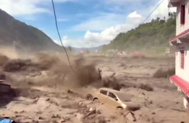
WEDNESDAY’S DEVASTATING FLOOD in the Tibetan border region of Nepal was likely caused by a glacier collapsing and falling thousands of metres into a river below, according to scientists who have been studying satellite images.
The violent torrent of water barrelled down rivers in the Himalayan region, sweeping away homes and leaving hundreds of people dead and more than a thousand missing.
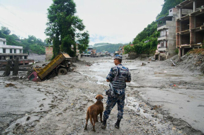
Entire villages have been destroyed and now lie half-submerged in mud.
Rescue efforts are continuing today with the assistance of neighbouring countries and the death toll continues to rise.
Two Irish tourists are among the missing, according to Nepal’s tourism board.
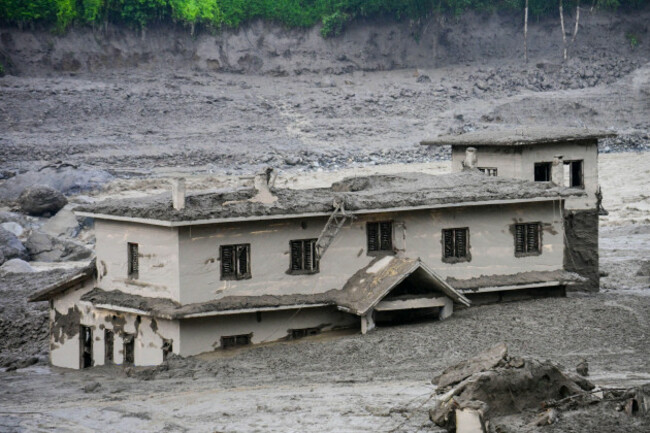
The glacier collapse was large enough to register as a seismic event, initially mistaken for an earthquake.
But after further analysis, the US Geological Survey determined that “the seismic event was instead a glacial collapse and debris flow, and that no earthquake had occurred”.
The collapse registered as a 5.2-magnitude “seismic event”.
“A large chunk of glacier fell from about 5,200 metres… into a valley,” said Simon Cox, principal scientist at New Zealand’s GNS Science.
It “transformed into this raging mass of debris… where it picks up rocks and sediment and trees and anything in the way and fires it on down through the canyon,” he told the AFP news agency.
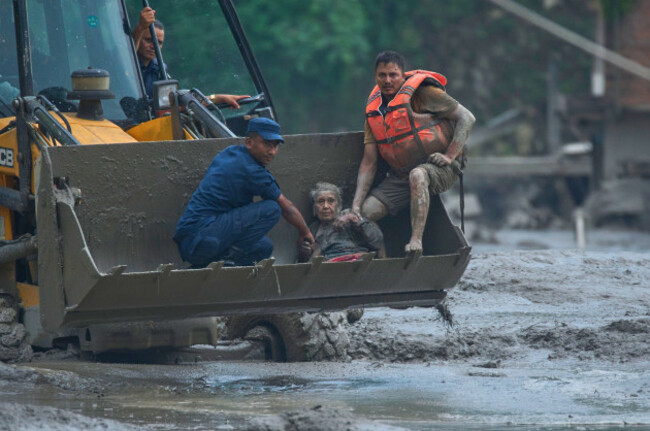
The wall of water first impacted a border post, as documented in terrifying CCTV footage showing mud and debris engulfing the area as people tried to flee.
Estimating just how much of the glacier collapsed will take time, Cox said, but it could range from “half a million cubic metres to tens of million cubic metres.”
On Wednesday, Nepal’s disaster management authority came to a similar conclusion and posted before and after satellite images of the area.
The agency said an initial analysis of satellite images indicated that “a glacier-inclusive flood occurred in the Lhende River due to a snow-rock landslide”.
Planet Labs को स्याटेलाइट तस्बिरको विश्लेषणका आधारमा गरिएको प्रारम्भिक अध्ययनबाट नेपाल-चीन रसुवागढी नाकाबाट करिब २० किलोमिटर उत्तरपूर्व नेपाल-चीन सिमानामा गएको हिम-चट्टान पहिरोका कारण ल्हेन्दे खोलामा गेग्य्रानसहितको बाढी आएको देखिएको छ। pic.twitter.com/kCAo9O1Zb0
— NDRRMA (@NDRRMA_Nepal) August 26, 2026
“We can look at satellite imagery taken before and after the event, and try and see what has changed, essentially looking for what is missing from the mountains in the ‘after’ imagery,” said Lauren Vargo, a glaciologist at New Zealand’s Victoria University of Wellington.
Soon after the seismic activity was recorded, a nearby water monitoring station stopped transmitting, Nepali authorities said.
Stations downstream began going offline one by one, though water was registered reaching up to 12.3 metres high in Kalikhola, near the Tibet border.
The flash floods in Nepal descended at rapid speed from surrounding mountain slopes, according to analysts.
— Sky News (@SkyNews) August 27, 2026
Footage captured the panic felt like the ground yesterday, with workers fleeing in terror in the Nuwakot District as the waves were approaching pic.twitter.com/krq8n190aW
Early speculation suggested a glacial lake outburst flood, or GLOF, a growing risk as glaciers melt due to climate change.
A GLOF occurs when a fragile debris wall holding back a lake of melted ice suddenly collapses.
Some experts suggested a GLOF might have been involved.
“Water does flow within glaciers and flows beneath glaciers,” said Adrian McCallum, a glaciologist at the University of the Sunshine Coast in Australia.
“But to my mind, the only reason why a large volume of water should all of a sudden flow down a valley is because it has been released,” he told AFP.
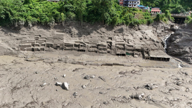
Other experts said they did not detect existing glacial lakes near the site of the glacier collapse, and theorised that water collected under the glacier might have cascaded down with the falling chunk of ice.
The falling glacier ice could also have briefly dammed the river, collecting water behind it that was released when it dislodged.
Summer glacier melt upstream, along with monsoon rains, would mean the rivers were already high, and the volume of water was also swelled by debris and mud picked up as it travelled kilometres from the initial collapse, Cox said.
Nepali authorities first received word of a flood around 9am local time, and began alerting areas along the Bhote Khoshi river to “stay on high alert and stay in safe areas”.
But it is unclear how many people received the warning, or how much time they would have had to respond.
“The reality is, if you are in a community underneath a large glacier and potentially a glacier lake where a GLOF could occur, then to some extent, it’s a ticking time bomb,” said McCallum.
And even for those receiving a warning, options would be limited, said Hatim Sharif, a hydrologist at the University of Texas San Antonio.
“Running will not help,” nor will trying to flee by vehicle, he said, because the mud and water moving at high speed form a lethal combination “like liquid concrete.”
The only solution is to climb up a hill, at least 20ft (six metres), he estimated.
It is not currently possible to tie the collapse of the glacier to climate change, but glaciers are retreating globally, increasing the risk of disasters like the one in Nepal.
“The biggest way to mitigate the risk would be to reduce our greenhouse gas emissions to limit warming,” said Vargo.
As temperatures rise across the world as a result of human made climate change, the Himalayan glaciers are melting at an increased pace. A major report by the International Centre for Integrated Mountain Development (ICIMOD) in Nepal found that since the 1970s the glaciers have thinned and retreated.
The Hindu Kush Himalaya Assessment found that if global greenhouse gas emissions continue unabated, two-thirds of the glaciers could melt by the end of the century.
Even if global temperature increases are kept to 1.5 degrees Celsius (the ambitious goal of the 2015 Paris Agreement), the assessment found that one-third of the glaciers would be lost.
With reporting from AFP

To embed this post, copy the code below on your site














have your say