Sign in. It’s quick, free and it’s up to you.
An account is an optional way to support the work we do. Find out more.
Sign in. It’s quick, free and it’s up to you.
An account is an optional way to support the work we do. Find out more.
WHATSAPP CHATS AND Facebook groups are lighting up around the country with people wondering what impact the ongoing fuel protests might have on their journey.
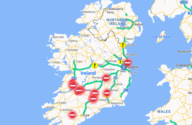
One resource that could help those planning journeys is Transport Infrastructure Ireland’s (TII) traffic map.
It outlines all the incidents, roadworks and congestion spots across the country in real time.
The traffic map can be accessed here and TII have advised that the protest is “mobile at times and can impact different regions at different times”.
As of 2.30pm, one of the most significant issues is the full lane closure of the M50 northbound at Junction 5 (Finglas).
Keeping track of the road traffic network is a mean feat on any day but TII staff have been especially busy this week as a result of the fuel protests.
So much so that The Journal asked TII how the map works, but staff there are too busy overseeing the map to speak about it at the moment.
However, in the FAQ section of the TII website, it notes that TII has a dedicated Motorway Traffic Control Centre who can be contacted to report any incidents.
TII also uses “Intelligent Transportation Systems” (ITS) to provide these updates.
The ITS includes traffic monitoring systems and CCTV to provide a real time traffic management service.
The traffic map contains a location of road closures and incidents in real time, as well as a comment on what the issue is likely to mean for motorists.
For example, a road closure update on the M1 in Co Louth, last updated at midday, contains a comment warning motorists that “significant delays” are likely and advising them to “use a different route”.
A statement on the website noted that there is significant distribution across the national road/motorway network currently impacting Clare, Limerick, Tipperary, Laois, Offaly, Kildare, Galway, Cork, and Dublin.
🚧 TII Statement on National Road/Motorway Network Protest Impact🚧
— TII Traffic (@TIITraffic) April 9, 2026
There is significant distribution across the national road/motorway network currently impacting Counties Clare, Limerick, Tipperary, Laois, Offaly, Kildare, Galway, Cork, and Dublin.
TII’s network operations… pic.twitter.com/BY66bDwBS7
TII added that it is working closely with the Garda Traffic Core to assist in managing the on-going traffic distribution.
TII meanwhile have requested that all road users leave the hard shoulder available for emergency services.
Health minister Jennifer Carroll MacNeill and the chief executive officer of the HSE, Anne O’Connor, meanwhile called for all approaches to medical facilities to be kept clear for emergency service access and for patients attending medical appointments.
Is a road traffic incident in your area missing from the TII traffic map? Let us know in the comments.

To embed this post, copy the code below on your site











have your say